ADOT has released Crash Facts 2018 in the later part of June (of 2019), as usual; this year and I did not order CDs but rather accessed the raw data online sometime in July (it will in relatively rare cases be updated after this).
The graphical crash map has been NOT updated and so continues to have years 2009-2017 ; the tool used to present the map, Google fusion tables, is being discontinued end of 2019, and I need to find a replacement.
The Fatality Grid has been reconciled and contains some specifics on every bicyclist fatality in Arizona from 2009-2018, and ongoing as discovered.
 There is nothing remarkable about this intersection; it is a prototypical arterial-arterial signalized intersection like many others in the Phoenix Metro area — this one is in the City of Tempe. Both streets are high-speed (45mph posted maximum limit); with two through lanes, a bike lane in each direction; in addition


 June 22, 2019; time unspecified; A hit and run driver driving on the shoulder killed a 77 y.o. male bicyclist.

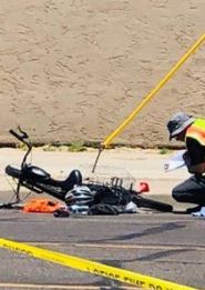 6/4/2019 Tues morning
 6/3/2019 morning peak time. Another* one. This time the NW corner of Ray and 48th St; a high-volume hi-speed arterial intersection. Hopefully no one was killed; but of course that would just be luck — the car drove right over the sidewalk to eliminate the pole.


 The political intrigue is fascinating; was Mesnard’s distraction bill just an attempt to derail a cellphone restriction? Did citizens of Arizona really have to wait 12 years for this — even as traffic safety got worse-and-worse — only because Farley was a Democrat and the legislature is controlled by Republicans?