There is no excuse for improperly engineered bike infrastructure. It takes on two forms, 1) simple straight-up wrong, and 2) “fake” facilities, those which masquerade as something they’re not; they’re in reality nothing more than shoulders, yet they are intentionally tarted-up to appear to be, and even be referred to as bike lanes (see e.g. Flagstaff, below).
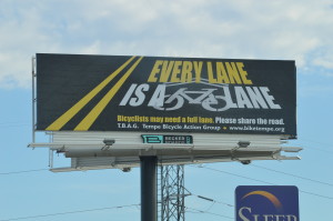
The reason there is literally no excuse is that there is no requirement ever to have dedicated bicycle infrastructure (for the purposes of this article, that means designated bike lanes). “Every lane is a bike lane” is more than a slogan — it’s true. Bicyclists have a right to use the roadway and not merely its edges (with exceptions for limited-access freeways).
Thankfully, most egregious examples have been either eliminated or never built in the first place in the Phoenix metro area; e.g. placing a through bike lane to the right of a right turn only lane.
There are, unfortunately, isolated examples of poor engineering. Even in, or perhaps particularly in, “Bicycle Friendly Communities“. The LABs criteria for select and awarding the designation suggests they weight the “5 E’s” but anecdotally they appear to heavily weight in favor of any dedicated bicycle infrastructure.
Bad Designated Bike Lanes
As I said, the designated bike lanes around here by-and-large adhere to proper engineering standards. There are instances where this is not the case, however…
Roosevelt Street, Tempe The BL on Roosevelt, south of Broadway Rd is severely sub-standard width for about 1,200 feet. It’s about 2.5 feet of usable space. The road otherwise is one through lane in each direction, perhaps 11′, plus a center continuous two-way turn lane. The center lane often doubles as a place for semi’s to dwell, e.g.while waiting to unload. Placing a too-narrow BL next to a narrow lane where there’s heavy semi/truck traffic, such as along Roosevelt is particularly ill-advised.
South, and north apparently?, the road is a couple of feet wider allowing for a normal-width BL. This is a particularly idiotic place to put too-narrow BLs; because of the industrial/commercial nature of the area, and because Broadway access to the interstate, there is copious heavy, semi-truck traffic. One October weekday mid-morning, I counted 6 semis in less than 10 minutes. This might actually be a fake bike lane, I don’t think there’s any symbols (at 40″, though wouldn’t fit; i.e. they would be on the gutter pan). This area appears on the MAG Bike Facilities Map as blue/”Bike Lane” (retrieved Oct 2016).
Hardy Drive, Tempe: The closest and most harrowing pass I’ve ever received on my bike in my lifetime was on Hardy Dr just south of Southern, City of Tempe. This is a designated bike lane. This is an example of a very poor design, the one general purpose lane is maybe 9′, the BL is maybe 3′ and the gutter is 1.5′; and that’s all between vertical curbs, because of the center island/median. This is presumably an example of a “shoehorn” BL; where the love of painted stripes drives people to do bad things, see this page for a diagram of why this design only works when the vehicles are mid-sized cars or smaller. Unfortunately heavy trucks and buses ply this street. The close pass I mentioned above was from a heavy-duty dump truck (SRP if i recall correctly).
Just north of this are incorrect SLMs (“sharrows”); click here for a streetview and here for what an SLM is supposed to look like. To add insult to injury they are placed too far to the right. And why would a straight going cyclist want to be to the far far right approaching a right turn only lane? And this is typical of the handful of SLMs on Hardy; it’s as if whoever did this had no idea what they should be doing.
And further north on Hardy between Broadway and University is an odd “innovative” sidewalk bicycle sidepath. Sigh, so much butchery to one little relatively quiet street.
ADOT / Sedona Bad Bike Lane SR89A

This particular area has a dramatically-undersized usable width in the BL, of about only two feet (the stencil is 40″ inches wide), and the whole thing is about only 4′ wide from the curbface.
The AASHTO Guide recommends a usable width (gutter pan seam to center of stripe) of four feet; and specifies the overall minimum width of a BL at 5 feet. This BL misses on both specifications. And those are minimum recommendations on normal streets, if very fast, and/or heavy truck traffic is expected (and I expect it is), more width is recommended.
Compounding the width problem is it’s next to a narrow travel lane; tempting motorists to squeeze by, instead of properly changing lanes. How wide is the travel lane there? I’m not sure but note how the dump truck pictured (dump truck’s body is 8′ wide) appears to nearly fill the lane; I would guess it’s 11′.
Also compounding the width problem is the area pictured looks like it has a significant downhill grade, demanding more width for safe operation.
[update 5/2017: it appears as though they were supposed to be 5 foot (3 + 2 gutter). This wouldn’t be great but it would be far more reasonable that what’s there, pictured, now]
Warner Rd at Kyrene, Tempe: This next bit is struck-through becasue CoT addressed Warner at Kyrene when it was resurfaced in 2016:The Warner Road bike lane is similarly, but not as badly, screwed up at Kyrene, see should-warner-road-bike-lane-have-a-combined-turn-lane. Ironically the substandard width there seems to be due to a widening of the Warner Road ROW near the intersection with Kyrene; coupled with either engineering mistakes, or as-built problems.
Fake Bike Lanes
More pervasive and more insidious is placing stripes where they shouldn’t be placed in the first place. These stripes then look virtually indistinguishable from Bike Lane stripes. However if they are, for example, too narrow to be a bike lane (a typical situation) or any other defect the official answer is simple: they’re not bike lanes. Motorists expect/demand bicyclists to use these fake bike lanes, though there is no legal duty to do so and best safety practices call for bicyclists to avoid them altogether.
As documented in some old emails in the comment below, the City of Phoenix has a policy to install edge lines when there’s not enough room to make a bike lane; thereby creating a fake bike lane. This is an improper use of EL, and not warranted by the MUTCD. Historical note, Greg Stanton was the councilperson at the time, and is now Mayor of “Complete Streets” Phoenix. Here’s a few in City of Phoenix, who seems particularly fond of this, at least in my area of the city, these are Chandler Blvd near 24th St, and Ray Rd around Sun Ray Park area:


Here’s a couple, the first from Guadalupe Rd at bridge over I-10 (below, See this comment for ADOT’s official response), and the second (below; click through to get other views. Dangerousness abounds at this mess) at Rio Saldo Pkwy at the 101 in Tempe. Both have to do with ADOT due to the freeway right-of-way. Rio Salado Pkwy has a designated bike lane both east and west of 101, that stripe sure looks like a bike lane stripe:

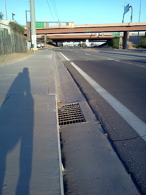
ADOT / Frontage Roads: Here is a classic ADOT shenanigan; seen on urban streets… An (apparently unwarranted) edge line makes a fakebikelane — Price Road in the vicinity of Warner Road. Scene #1, southbound; looks wide enough to be a bike lane, but isn’t; plus there are drain grate that further narrows the usable width. Scene #2, northbound; width varies, it’s particularly narrow here with maybe 2′ of usable space; and that’s next to a relatively (about 11′) lane. Also weirdly the gutter pan is narrower than usual (ADOT pans are usually 24″ wide; these are only about a foot, which is again weirdly even narrower than the normal 17″ typically used throughout MAG cities)
Other ADOT-ness: This is Ray Road as it passes over SR202. ; the drainage grates are right in the middle of what would be bike lane; taking up ~ 2feet of the perhaps 5feet of space. There are designated bike lanes immediately both east and west (Cites of Chandler and Tempe) of here.
Rio Salado between Priest and Hardy, City of Tempe (no ADOT to point the finger at this time) is a flaming fake bike lane. Why not a designated bike lane? Well there just wasn’t enough room (to have 2 lanes in each direction plus a bike lane) so someone thought it would be a good idea to use an (I presume) unwarranted edge line. Sure enough, a CoT staffer, years ago (2010?) told me this was not a BL but rather a “wide curb lane with shoulder stripe (edge line)” — what a cute phrase, I had never heard that one before. I noticed this when i was riding in the (fake, as it turns out) BL and a transit bus passed me within inches without bothering to change lanes. #fakebikelane #edgehazard
McClintock Drive approaching Elliot Road, Tempe. This is not just a short distance, it extends from McNair to Elliot, perhaps 900′. The whole corner is odd, Tempe frequently drops the bike lane approaching intersections to provide space for a right-turn-only lane. On this corner, for some odd reason somebody decided that McClintock needed three through lanes in each direction, but only for a short distance. The same issue exists on the other side; i.e. northbound McClintock, north of the Elliot intersection. [picture also here]
Below is the full official response from City of Tempe; as I feared, officially speaking they claim this isn’t a designated bicycle lane, rather the white stripe is an edge line (see the difference?). To add confusion this is on a street with actual designated BLs both south and north of here. In any event an edge line there would almost certainly be unwarranted per MUTCD. [no updates yet as of this writing in June 2020; but i just noticed the response was almost 6 years ago now; and it referred to it was going to repaved “soon”; so far nothing yet. There appears to be plenty of space to do something sensible][There is a copy of a city of Tempe spreadsheet here listing timelines for resurfacing]
This arrangement is far too narrow to ride within safely with any sort of bicycle; and beyond creating a hazardous situation for bicyclists, creates a liability for the City of Tempe.
If there’s really not enough room to make a properly-engineered bike lane, then don’t have one; as was done on the other side of Elliot (so, northbound McClintock approaching Elliot; the bike lane was discontinued).
 Greenfield Road btw Southern and Pueblo, Mesa: I got an angry email about bicyclists who “won’t stay in their bike lane”, OOPS, sure enough, not a bike lane. Just a fake bike lane. Try telling that to the ignorant complainer… I did and he was having none of it. Something about taxes. (p.s. this is in the CoM, I got burned by that once before, there was an edge line on a collector that turned out to be in a county island).

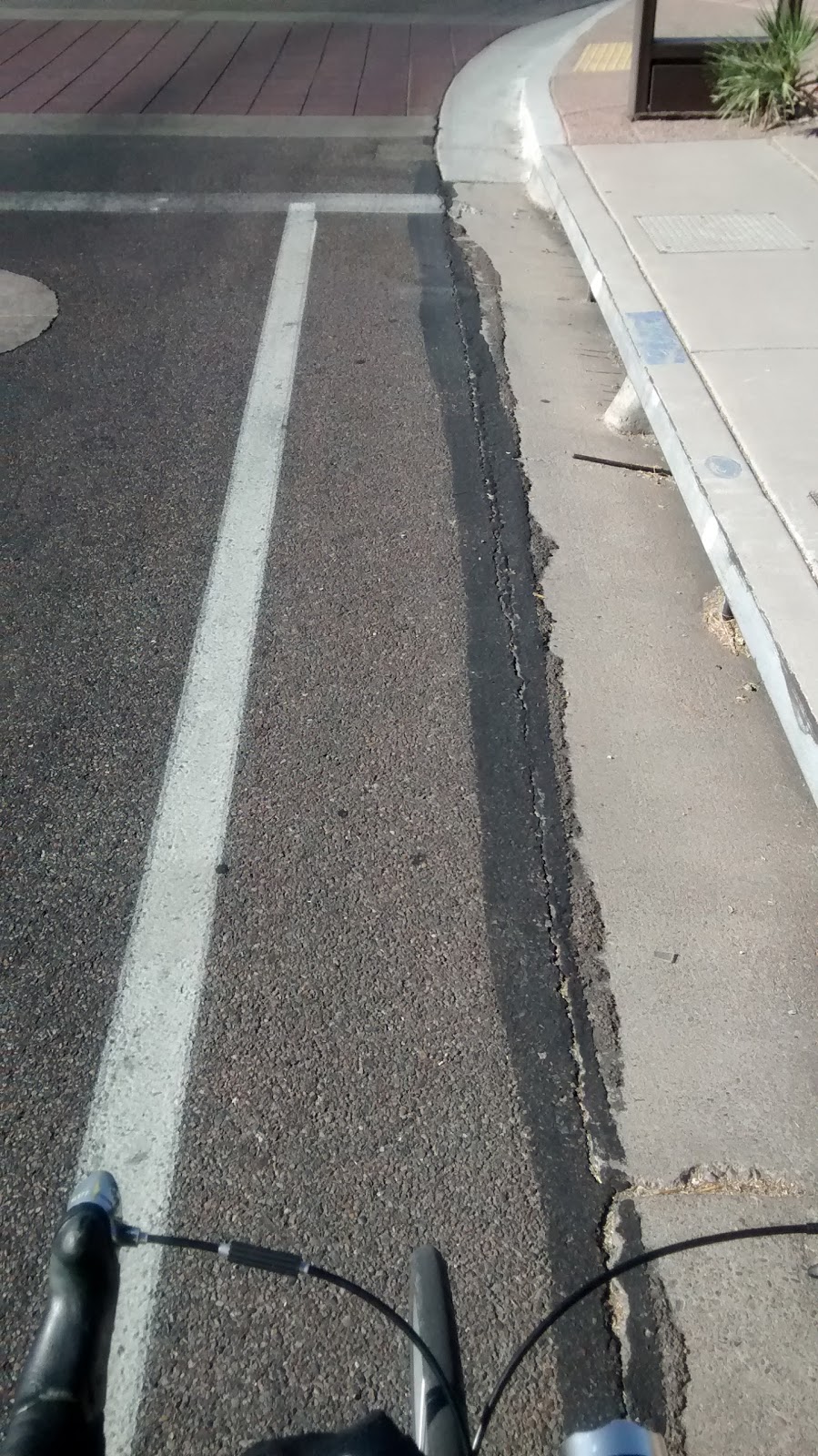
[UPDATE; this segment, between Southern and Broadway has been corrected in late 2017. Though, other segments of Mill remain problematical] Mill Avenue, Tempe: Mill Avenue, just south of Broadway Road. City of Tempe. Has drainage grates taking up most of the space in the fake lane. Apparently unwarranted. This area appears on the MAG Bike Facilities Map as purple/”paved shoulders” (retrieved Oct 2016).
 Rt.66 Flagstaff. This example is near Switzer Canyon: But I must single out the city of Flagstaff for being especially duplicitous on their definition of Bike Lane. They mix real bike lanes with fake bike lanes on their map, using the same color key so there’s no way to tell. Looking through their Active Transportation Plan Proposal (I was looking 12/2017) they carry the charade one step further, they count fake bike lane mileage together with actual bike lane mileage.
There are 131.6 miles of existing bike lanes on Flagstaff streets.
Of these, about 72 percent are officially designated with bike lane signs and pavement markings. The remaining 28 percent are shoulders that are defined by a stripe along the edge of the road and usable by bicyclists, but not officially designated as bike lanes with pavement markings or signs.
This particular segment (pictured) is listed in the ATP map as a “missing bike lane”; but regardless, it’s a fake bike lane. #fakebikelane #edgehazard
tempe311 case 252257 / 377645 and was submitted via computer (not phone) on my acct. Oh, and by the way, if the official answer it, “as things turn out, this isn’t a bike lane at all…”; it would then appear the edge lines are unwarranted (was there an engineering study done to support their use?):
See MUTCD sections 3B06 and 7, Edge Line Pavement Markings, and Warrants for use of Edge Line Markings.
Here’s the official response —–
Also of interest, the BL dropping has been addressed in 2020 by changing from RTO to combined-use that allow thru bicyclists to continue straight.
A second salvo (is this a “war on edge lines”?), sent via ADOT contact form (submitted July 5, 2014)…
Use of Edge Lines #1418636474 7619355241
Here’s the reply:
ADOT Phoenix District did obliterate edge line on Price Freeway frontage road north of E Apache blvd (you can still make out a bit of the paint in the photo) after I asked them to justify EL and they couldn’t. This after a bicyclist had complained that he caught his wheel in the gutter pan seam, and fell, while he was riding in the “bike lane.”
— extracted from a CaD! thread —
It sounds like Ed is asking specifically about whether the guidance in the Federal MUTCD requires an engineering study for edge lines on an urban street. After all, the guidance says that edge lines should be placed on other than “[r]ural arterials and collectors with a traveled way of 20 feet or more in width and an ADT of 3,000 vehicles per day or greater” where an engineering study indicates such a need.
As I understand this language, based on my PhD in Transportation Engineering and 35 years of experience as an assistant professor of transportation engineering, public agency traffic engineer, consulting traffic engineer and traffic engineering expert witness, I would say that an engineering study IS REQUIRED to install such an edge line, pursuant to the guidance in 3B.07.
The confusion is the word “should” in paragraph 02. But in my opinion, since the title of the section is “Warrants for Use of Edge Lines,” if you install an edge line is installed on an urban street or highway, then you better have a darned good reason for doing it and you must document it. My testimony to such reasoning has helped win cases based on similar language for other traffic control devices.
… I suggest you take a copy of 3B.07 with you when you speak with the city traffic engineer and ask for the engineering study supporting the placement of the edge line on that street. If there is no engineering study, then request that the edge line be removed.
A couple of historical email from City of Phoenix regarding use of edge lines on urban arterial. my emphasis added… These quotes make plain that the city is using edge lines in lieu of a bike lane, because there isn’t enough room for a real BL, they went for a fake bike lane instead.
From briiana.leon@phoenix.gov Thu Sep 01 15:58:54 2005
Hello Ed:
The white right stripe is an edge stripe. We would love to have had bike lanes on Ray Road but unfortunately that section of roadway was built before our standard cross section was implemented that includes bike lanes on all new arterial and collector streets. The edge stripe was probably installed as a compromise since bike lanes could not be accommodated. The narrowing of the lanes will also slow down traffic on the roadway.
Unfortunately, the lanes are as narrow as they can be and cannot be narrowed any more to squeeze in bike lanes. The street is signed as a bike route since many cyclists use that stretch and it lets drivers know to possibly watch out for cyclists on that stretch of roadway. If we could have squeezed in bike lanes on Ray Rd we definitely would do it but it is just not feasible. I hope I answered your questions and if you have any additional questions or concerns please contact me. Thank You.
Briiana Leon, P.E.
Traffic Engineer II
City of Phoenix – Street Transportation Department
—– Original Message —–
From: greg.stanton@phoenix.gov
To: Ed Beighe
Sent: Wednesday, April 11, 2007 3:46 PM
Subject: Re: Councilman Greg Stanton comment / 3 foot signs.
Dear Ed
Thank you for your concerns regarding bike safety in Phoenix.
You voiced in your email that Phoenix has made choices in the past
that exacerbate the friction between cyclists and motorists because of
the narrow traffic lanes force motorists and cyclists to share the same
space of the roadway.
Phoenix has strived since the late 1980s to improve conditions for
cyclists in Phoenix. At that time there were only approximately 75
miles of bike facilities within the roadway right of way with much of
that being on sidewalks or collector streets. In 1987 the Council
approved the Phoenix Bikeway Plan which created a plan for a
comprehensive bikeway network consisting of more than 700 miles of new
bikeway facilities. Phoenix also adopted new roadway standards in 1994
that added bike lanes onto the arterial street cross-section.
Since the late 1980s, Phoenix has built over 550 miles of new bike
facilities which most are located on arterial streets. Many existing
streets were retrofitted to add bike lanes where it was feasible and
bike lanes were added to new streets when they were constructed. In
addition to bike lanes, several bridges and tunnels have been
constructed to connect facilities across the freeways or to eliminate
motor vehicle conflicts at difficult at-grade street crossings. Phoenix
was one of Bicycling Magazines Top Ten Cities in 1995 and Phoenix has
continued make positive progress since that time.
The new roadway standards adopted in 1994 not only added bike lanes
onto arterial streets, it did make interior traffic lanes wider. The
previous arterial street standards provided lanes that were 10-feet wide
for interior lanes and 12-feet wide for curb lanes. The new roadway
standards increased the interior lane widths to 12-feet on most arterial
streets, but maintained the curb lane width at 12-feet. Most of the
streets in the Ahwatukee Foothills area and in Phoenix prior to the
mid-1990s were constructed based upon the previous standard, which did
allow interior lanes of 10-feet wide and curb lanes of 12-feet wide.
The city has tried to enhance the safety of city streets for
cyclists by adding bike lanes onto arterial streets wherever it was
possible. The initial effort was to retrofit bike lanes onto existing
streets by eliminating an “unneeded” traffic lane and converting it into
bike lanes. Most of the streets with bike lanes in the AF area fall in
that category. Some streets were designated as bike routes where it was
impossible to add bike lanes. These streets are posted with BIKE ROUTE
signs only. The notable exception is Ray Road where an edge stripe was
added to encourage motorists to the drive further to the left in the
hopes to provide more space for those cyclists that desire to use Ray
Road. Other than the segment between Piedmont and Guadalupe, 48th
Street has continuous bike lanes from Pecos Park to the Pointe where the
streets become private streets. Bike lanes could be added to that
segment of 48th Street if it were reconstructed, but it is an expensive
project that is currently unfunded. Compared to other areas of the
Phoenix, the Ahwatukee-Foothills area is one of the more cycle
friendlier areas.
I hope this answers your concerns and questions regarding bike facilities, but if you still have questions you can call my office or Srinivas Goundla at 602-495-3697 or John Siefert at 602-262-4690.
Here are extracts from a 2008 thread from chainguard mailing list regarding edge lines —
Ed,
Richard Moeur chairs the Bicycle Technical Committee of the National Committee on Uniform Traffic Control Devices and works for Arizona DOT in Phoenix. I asked him if he had a response to your question. Here is
our exchange:
Richard Moeur wrote:
> Bob Shanteau wrote:
>> Ed Beighe wrote:
>>> I’m wondering if anyone can point me to references for lane edge
>>> stripes on urban streets (do’s and don’ts. why’s and whynot’s). My
>>> city has a penchant for striping the “leftover” space — which might
>>> vary from as little as zero feet (stripe at the joint with gutter
>>> pan) to maybe two or three feet. For the longest time i just thought
>>> it was an annoying curiosity. Then I found out from an official
>>> source that it is intentionally done to “help” cyclists.
>>>
>>> Or, to re-state: How can I get my city to stop helping?
>>>
>>> Sample pics here: http://azbikelaw.org/articles/RayRoad.html
>>>
>>> These non-bike lanes, as you can probably imagine are widely
>>> perceived as bike lanes.
>> Richard,
>>
>> Apparently this guy is from Arizona. Is there anything different
>> about Arizona practices from the federal MUTCD?
>>
>> Bob Shanteau
> I can’t speak for local jurisdictions, but ADOT doesn’t encourage or
> endorse these practices (to my knowledge). Then again, ADOT has little
> influence on arterial street design in Arizona.
>
> If anyone does ask me if there should be a striped space for potential
> bicycle use to the outside of the right travel lane, then I recommend
> that the space meet all AASHTO guidelines for bike lanes – otherwise
> the agency could be in some difficulty if the edge area is too narrow
> or if a bicycle crash occurs in the area. If there isn’t enough room,
> I recommend either no stripe, or to adjust all lane widths until Green
> Book and Bike Guide recommendations are met. This can be a problem on
> older roadways, given Phoenix’s past history of initially designing
> these roadways (up until 1990 or so) with 10-11 ft lanes to save right
> of way & construction costs. Newer streets in Phoenix and other cities
> are typically designed with space for cyclists, but there are many
> miles of arterials which can’t be restriped to meet all guidelines
> without either removing lanes or moving curb lines (which as we know
> usually is cost-prohibitive).
>
> Richard C. Moeur, P.E., L.C.I., WC7RCM
> Practicing Traffic Engineer (I’ll get it right someday…)
> Phoenix, Arizona, USA
> “Life is just one W1-5 after another, until the W14-1”
> The opinions expressed are not necessarily shared by any organization
> with which I may be associated. 🙂
> Websites:
> http://www.richardcmoeur.com
> http://www.trafficsign.us
> – – – – – – – – – – – – – – – – – – – – – – – – – – – – – –
I just came across the pavement marking manual for Tuscon and Pima
County: http://www.dot.pima.gov/trafeng/DesignManual/PavementManual.pdf . I know that you are near Phoenix, but this might help get your point across. In particular, it page 77 of this manual shows edge lines only for paved shoulders more than 4 feet wide.
Bob Shanteau
Tempe 311 [not submitted; pending outcome of email Shelly Seyler 2/22] For Mill Ave / Near Broadway (see photo)
Edge lines on city streets the look like bike lanes are wrong and should have never been placed.
They present operational and safety problems for bicyclists, and increase motorist harassment of lawfully operating bicyclists.
They are presumptively UNWARRANTED per MUTCD (3B.06) because, I assume, no engineering study has been done (or has the City conducted a study at that location warranting their use?).
Resurfacing is an excellent time to correct problems, saves $’s! The City of Tempe is apparently preparing resurface here later in 2017(“pavement preservation”) along this area. http://www.tempe.gov/home/showdocument?id=48446
If City Tempe wants a stripe there make it a real BL with at least 4′ of USABLE space as recommended by AASHTO; otherwise dump the stripe.
Do not simply reinstall this unwarranted stripe.
For safety, especially pedestrian safety, the city should be encouraging reduced peak motor vehicle speeds; and if there is to be no separate, designated space for bicyclists, you should cause peak speeds to be lower, and install BMUFL (Section 9B.06 Bicycles May Use Full Lane R4-11 ) signage, along with Shared Lane Markings ( Section 9C.07) — since that’s what this is, a shared lane.
There’s no excuse for bad, or worse yet in this case, fake bicycle infrastructure.