Attention bicyclist advocates: resist the urge to desire dedicated bicycling facilities when they won’t fit safely.
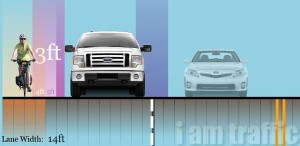
In the accurately scaled example diagram below (visit iamtraffic.org to tweak the dimensions and vehicle choices. A very cool tool!) a cyclist riding an upright bike is riding centered in a 5′ BL w/curb abreast of a Ford F-150 driving centered in the right general purpose travel lane (and DON’T say “car lane”, or somesuch).

Notes on the illustration
These dimension are generally viewed as be minimally acceptable for safety in areas with curb, see e.g. AASHTO Guide for the Development of Bicycle Facilities
The recommended width of a bike lane is 1.5m(5 feet) from the face of a curb or guardrail to the bike lane stripe. (2012, p. 4-14. Then goes on the state reasons when BL should be wider)
Along sections of roadway with curb and gutter, a usable width of 4 ft (1.2 m) measured from the longitudinal joint to the center of the bike lane line is recommended (2012 p. 4-15)
Note in the illustration is slightly below the 4′ of usable width recommendation; because typical city gutters are something a little more than 1′ wide (as mentioned below, 1.5′ pans are typical for the Phoenix metro area). And note this is all presuming there are no drainage grates (or anything) protruding beyond the gutter pan). Any such hazards would necessitate the overall BL be more than the 5′ shown.
The more insidious problem is that of the dimensions of the travel lane. An 11′ travel lane is considered generous by city standards, yet we see that many vehicles being driven centered in that lane will not pass at the legally required 3′ of clearance. Many vehicles would need to be driven consciously to the left of their lane in order to pass at the minimum of 3′. And by many I mean many — the Ford F-series pickups are the most popular vehicle models in the US, and have been so for decades. Larger vehicles, medium and heavy-duty trucks and buses simply cannot pass legally without changing lanes — will they?

Cyclist’s minimum operating space
The iamtraffic illustration above accurately depicts what the AASHTO Guide calls the physical width of (an adult on a single-track, upright bicycle) cyclist of 2.5 feet and a minimum operating width of 4 feet . The operating width is depicted by a pale yellow highlight which is there but difficult to see because there is so much encroachment at the illustrated width (a 5′ BL, next to a 11′ travel lane).
The FHWA Bicycle Road Safety Audit offers these guidelines and explanations:
On-road accommodations: bicycle accommodations should consider the full operating width of cyclists, not just the physical width. The operating width for cyclists may increase because of speed, wind, bicyclist’s handling skills or shy distance from curbs, gutter pans, drop-offs, guard rails, railing, car door swing, and other features.
On-road accommodations: …Bike lanes or separated facilities may be more appropriate on high-speed, high-volume roads. Adequacy of the separation distance of these facilities is a function of vehicle speed, volume, and composition. Beyond meeting minimum standards, the width of on-road facilities should consider the wind impacts from passing heavy vehicles.

In the diagram, the cyclist, and her minimum operating space, is shown centered in the 5′ bike lane — this is not necessarily realistic due to the inevitability of inconsistent gutter pan joints, especially when exacerbated poor maintenance (like the photo at right), along with debris that naturally collects at any road’s edge and no amount of sweeping can eliminate (example of another maintenance problems , example of sweeping).
Baseline Road
There is a section of Baseline Road, between about 40th to 46th Street (why not 48th St / the city limit? East of 48th is City of Tempe, by the way) which lacks BLs. The City of Phoenix installed BLs west of 40th Street (to ??) some years ago.
The nature of this street is it is a high speed / high volume (with significant heavy truck traffic), posted 45mph limit primary arterial with 3 through lanes in each direction. It sometimes becomes congested, I guess especially eastbound due to I-10 interchange just east of City of Phoenix. In this section the east and west lanes are separated with a raised median.

The dimensions are apparently 35′ curbface to curbface (for each direction, separated by a 20′ raised median); divided something like 13 / 10 / 12 inclusive of gutter pan (see CoP email from 2006, below). Here is a streetmix of one proposal for squeezing a BL in there (that one assumes the gutter somehow gets incorporated into the BL, either by paving over it, or digging/cutting it away).
There is no honest / ethical way to rearrange 35′ of space and maintain three through general purpose travel lanes and a BL. As we’ve seen above, a minimally acceptable BL plus one travel lane takes up 16′, and it is unlikely the city would ever install two travel lane (one next to a curb) in 19′ of space.
Moreover because of the high speeds plus expected heavy truck/bus traffic, a wider than 5′ BL is indicated.
There are only two ways to add BLs to this strech —
- Reduce the number of through travel lanes in each direction from 3 to 2, or
- widen the road
Besides AASHTO, there are other “guides”, e.g. the NACTO Urban Bikeway Design Guide: says on the topic of BLs:
On streets with high traffic volume, regular truck traffic, high parking turnover, or speed limit > 35 mph, consider treatments that provide greater separation between bicycles and motor traffic such as: Left-side bike lanes (not applicable in this configuration), Buffered bike lanes, or Cycle tracks
City of Phoenix, by the way, is some sort of founding member of NACTO. So 3 of those 4 items apply to Baseline Rd, so a Cycle track, or Buffered BL should be used to provide “greater separation” — either of which would require far more space than a 5′ BL.
—
 Here are some more graphics; this one shows lane sharing in 14′. The bicyclist’s tire is 2′ from the edge; i.e. a FRAP, and the pickup is literally as far left as possible — there is less than 3′ clearance. You can regenerate other graphics (e.g. with a car, which shows enough clearance, or a Truck which show the two practically touching). I will check with iamtraffic, i am quite sure you/we can use their graphics so long as we credit them.
Truck/Bus Dimensions

Some diagrams in The Influence Of Lane Width On Bus Safety , a report prepared for Florida DOT, may be useful. In Figure 8.3. D is 8.5′, E is 1′. Recommended lane widths for curbed roads, they came up with 12′ lane (dimension J in the figure) next to G=5′ BL, THAT’S SEVENTEEN FEET (including a 1.25′ gutter, marked as A) as a recommended width — presumably a recommended minimum width because they fudged in ignoring the right mirror dimension, in other words, the width of the mirror is ignored for the purposes of a 3′ minimum passing clearance. There is also a second fudge in that the operating space depicted (B= 3.75′) is less than AASHTO recommendation of 4′. A third potential fudge is underestimating the width of the gutter pan (A = 1.25′), around here they seem to be more like 1.5′. So sort of a worst-case fudging is an extra 13 to 18″ (10 to 12 inches for the right-mirror, and 3 to 6 inches for the bicyclist’s operating space) is really required to provide a minimum clearance of 3’… Which is not to say the 3′ can be assumed or guaranteed to be safe. The law, quoting AZ law is that passing drivers must allow a “…safe distance between the motor vehicle and the bicycle of not less than three feet”. What this all adds up to is one quite wide lane; if you’re planning or hoping to have legal and safe passing in-lane next to a BL.

Other illustrations may be helpful, E.g. “Figure 2.10. Buses not able to maintain a 3-foot clearance law from the bicycle for a 14-foot wide curb lane”.
Baseline Road is a truck route (see this article for explanation of truck routes in the City of Phoenix); and is not only an arterial, but a principal arterial, and this stretch is located adjacent to the confluence of two major freeways: the I-10 and US-60. Expect lots of truck and bus traffic.
Apache Trail 3 to 3+BL re-striping
This is just a coincidence, but I noticed that according to google street view BLs appeared on Apache Trail in the vicintiy of Ocotillo, Apache Junction sometime after June 2013 but before July 2015.
The road was used to be 3 lanes in each direction plus left turn pockets with a (very wide, and not raised) median — but was according to google estimates 38′ wide. So they did something like 11/11/11/5′ (including gutter)… which quite minimal as shown above (and check out the PU in that particular street view). An 11/10/12/5′ split would be much better. And since there’s no curb at the median, if you really wanted to do usable segregated bike facility: 10/10/12.5/5.5 (i.e. a minimal BL — 4′ of usable space plus 1.5′ gutter pan) would be good — trucks and buses could pass within lane and still give cyclists in the BL the required passing clearance.
Sidenote: the BL symbol appears to be non-standard; the standard symbol is 40″ wide; this one looks to be only maybe 24″???
Broadway Lane Diet
Info on the Broadway Road lane diet has been moved here; the geometry is arguably shoehorn, 11′ travel lanes next to a “5 foot” BL. I put that in quotes because that’s shorthand for saying it’s a 3.5′ BL next to a curb/gutter. (it’s even as little as 3′ in some places).
McDowell Road (Scottsdale) Proposes Shoehorn BLs
This proposal was under consideration in September of 2017. The plans are to add a BL on McDowell Road between 64th St (Galvin Pkwy) and Pima Road, which would be a distance of 3 miles. It will require reworking some or all of the existing medians. The stretch also has an unusually large number of weird, brief RTO lanes, in addition to the expected RTO lanes at major intersections.
Do see the comments link, above, but in brief these are generally shoehorned in at nominally 5′ (including a gutter) BL next to an 11′ lane, but have some particularly onerous trouble spots, including a 4′ bike lane sandwiched between an 11′ lane to its left, and a 9′ lane to its right.
40th ST, Loop-202 to McDowell Road; Phx
just saw this today after the fact; refers to a public meeting in May 2019. 40th ST, from 202 to McDowell. This stretch is, by the way, only about 1/4th of a mile.
Looks like they’re wanting to shoehorn in bike lanes all over town!
www.phoenix.gov/proposed-modifications-to-existing-roadway-striping
Design proposal for May public meeting pdf
In sum; the existing 52′ curb-to-curb is comprised of 5 thru lanes and a center turn lane; (This is a pretty gross road! )
proposal would eliminate one of the 10′ thru lanes; turning it into two 5′ BLs (that’s 5′ including gutter; so to be honest it’s 3.5′ of usable space in the BL, sub-standard).
Advice on Shoehorning from the FHWA
Released advice on how to shoehorn in bike lanes in Incorporating
On-Road Bicycle Networks into Resurfacing Projects. [.pdf version] Things like this, of course, sound very reasonable, p.2:
…transportation agencies are encouraged not just to meet the minimum requirements of providing bicycle facilities, but to go beyond minimum standards…
For travel lanes, the smallest allowable width; which they say would tend to be 10 or 11′ (p.23). For BL’s I don’t think they say(?) — I would presume they mean “5 foot” BLs — which tends to mean 3.5′ of usable space next to a 1.5′ gutter/curbface. (which is actually less than the 4′ usable space recommended in the AASHTO Guide… as the minimum operating space for a design-bicycle/bicyclist, see figure, above from the Guide). They also refer to a “standard width” BL; so anyway, i haven’t found where they say what they exactly mean by standard and minimum width BLs.
There are several, very weak, cautions and warnings, mostly collected on p.33:
3.4 | Practices to Avoid
There are several practices that should be avoided when resurfacing streets and roads. Some of these can actually make conditions worse for bicycling than simply returning the roadway to the same lane configuration as before resurfacing. In many cases, minor modifications to project plans can mitigate problems for bicyclists.
Overuse of Design Minimums
Methods discussed in this workbook call for flexibility in the use of design criteria, particularly travel lane widths. Without reducing travel lanes to a minimum width, it will be difficult to use that particular method effectively. It is not necessary to use minimum widths for an entire street cross-section. If a travel lane is proposed with a minimum width, the adjacent bike lane should be standard width. If minimum widths are used in combination (i.e. minimum width travel lanes and bike lanes), consider the following…
Some Details about Gutter Pans
Gutter pan details moved to article about usable-width
Some other actual measurements
I’ve begun to note actual widths at places of interest. A 700C-25 wheel is 2015mm = 6.906 feet. It’s pretty easy to measure revolutions, so for example 5 revolutions = 34.5′ — a common width for curb-to-curb for 3 through lanes in the City of Phoenix where there are raised medians.
Ray Road near Sun Ray park = just shy of 5 revs = 34 feet. In its present configuration, it’s ~ 11 / 9.5 / 9.5 / 2.5 / 1.5 (lane 1 / lane 2 / lane 3 / asphalt shoulder / gutter; and is very much a #fakebikelane). 34 feet is a very unfortunate choice of dimension. A minimal BL would be 4′ plus 1.5 gutter, leaving 3 lanes in 28.5 feet (= 9.5 feet). Something the city would likely never do because, you see, it’s important for safety that general purpose travel lanes be wide enough, but bike lanes or fake bike lanes do not need to be. Note that as with many raised medians there is “extra” space in the median — I mean it is wider than one lane. The median here appears to be about 15 feet.
Mountain Parkway btw Ray and Chandler Blvd (#mpw)

This one popped up right near my house, I had no idea. After the recent microseal was applied in August 2019, the striping was rejiggered on Mountain Parkway between Ray Road and Chandler boulevard, City of Phoenix to add a bike lane. There two general purpose lanes were both squeezed to place a bike lane.
This is an arterial road with fairly low volume; two through lanes in each direction with a fully raised median, left turn pockets, and there are no right turn lanes. (the city’s volume/count maps seemed odd or off but the most recent figures from circa 2015 show about 6,000 AADT in each direction along this segment. It is a lightly-used arterial in any case)
In terms of bikeway connectivity, this segment was quite an obvious missing link. Ranch Circle, to the north of it has a bike lane, and 40th Street to the south of it as a bike lane. (somewhat confusingly, the same contiguous street is called 40th Street, Mountain Parkway, and Ranch Circle North)
So the width of the bike lane itself seems okay but not great; UPDATE ok, not really. I went back with a tape measure —

46″ usable plus 16″ gutter makes total width slightly over 5’as measured from curbface; with the usable being slightly under the minimum of 4′. Worse yet is the exact dimensions wander a bit; some probably just due to normal as-built variance, and other as the stripe meanders away from the guide-stripes; this reduces the usable width from the 46″ measured above to as little as perhaps 42″ in some spots.
Unfortunately the right-hand general-purpose lane now is only like 10 feet; I measured it a couple of places and it was a couple inches under 10′. So it’s a shoe horn
A quick word about gutter pans; it seems ridiculous to be wondering about 1″ but when you squeeze things every inch matters. I thought Phx used the MAG gutter Type A which is 17″ but it definitely seems more like 16″, even though the recent micro-seal has blurred the gutter edge — but it’s always there lurking, waiting to present a maintenance problem in the future.
The left lane is also ~ 10 feet from the centerline to the left gutter edge. Meaning it’s really closer to 11 1/2 feet total, I would really rather them squeeze the left lane rather than a lane adjacent to a bike lane. This iamtraffic graphic illustrates the problem elegantly; there’s not enough space between the usable space of the bike lane here (4′) plus the adjacent lane (10′) for common vehicles (light-trucks and SUVs; as well as anything wider) to pass legally in-lane. Overtaking drivers of these vehicles would need to change lanes, at least partially, to make a legal pass/overtake.

If my guestimations are correct, that would make each direction 27′ curb to curb. (more careful measuring, but limited by traffic safety concerns; lead me to believe it’s closer to 26′ = 1 + 10 + 10 + 4 + 1)
Curiously, I think that’s the same width as Ray Road west of Mountain Parkway, which continues to have the edge line (whereas Mountain Parkway never had an edge line for whatever reason) after the micro seal job that was done at the same time as Mountain Parkway.
The hill is a prominent feature, along this segment; downhill use of the bike lane should be avoided; move into the general purpose lane instead; due to high speeds (~ 30mph).
The info i got from CoP says, but not specifically curb-to-curb is 26′ (they say 11, 10, and 5):
---------- Forwarded message ---------
From: Bike STR <Bike@phoenix.gov>
Date: Fri, Sep 27, 2019 at 1:41 PM
Subject: RE: dimensions on Mountain Parkway

Good afternoon! We hope you can accept our apologies on the delayed response. I have confirmed with the bicycle team that this new roadway striping resulted in the following dimensions; 5’ bike lanes, 10’ drive lanes next to bike lane, 11’ drive lane next to median
We hope this is helpful. Please let us know if you have any other questions! Warmest regards,
Ashley Patton
City of Phoenix Street Transportation
I’ll point out again, there is plenty of room in the existing road for not just BLs but slightly oversized BLs along with more-standard travel lane widths, were it not for the raised median. The curb-to-curb for the whole road (both directions) appears to be 68′ (= 26′ time two plus 16′ for the median). See Warner Road in Tempe for a good example of how to apportion 68′. Ahwatukee is littered with arterials with such dimensions (and medians); Chandler also has several (McClintock, 56th/Priest). This chosen width, 26′ appears to be a hang-over from Traffic Engineer’s great love — once upon a time, anyway — of 12′ travel lanes (12 + 12 + 1 + 1 = 26), and can’t accommodate two lanes plus a BL no matter how you slice it without expensive median reconstruction.
Lanes which are wider than normal, but not wide enough to share side-by-side, such as the 13′ lane (minus gutter, so ~ 12′) referred to above by a presumably well-meaning but misguided individual are DISASTROUS for bicyclists, the “sharing” of the lane turns out looking like this illustration, if the bicyclist is lucky, lots of very close passes:
If the city is unwilling to make room for bike lanes, then the only other way to safely accommodate bike traffic on the road is to mark the right lane with a sharrows, add BMUFL signs, and reduce the speed limit to 30 mph or less, preferably with some traffic calming measures to encourage drivers to slow down.
From Article by Wayne Pein 2012 AASHTO Bike Lane Width
I don’t know where that pic was taken, but here you can see from the various dated street views, 2012 seem to be the worst condition, the deterioration of the asphalt surface covering of the concrete gutter pan
Also extracted from the same article/paper, Pein’s critique of AASHTO BL widths,
There are also many pearls of wisdom in another of Pein’s whitepapers, How wide should a wide lane be?
Road users need to impress upon the City traffic engineers that this “needs to be killed”:
Other voices: https://gettingaroundsac.wordpress.com/2015/02/04/14-foot-lanes/
It’s not completely clear, but reading this plus the cartoon leads me to believe the author/cartoonist, Ian Lockwood, would shoehorn in a BL anywhere.
ADOT Roadway Design Guidelines 2012 Edition (which appears to be current with the most recent, 2014, updates and revisions —
Page 300-11, section 302.4 — Shoulder Width, Table 302.4: Urban multi-lane divided or undivided 5 or more lanes, (what about Urban undivided 2-lane?), or Frontage Roads (2-lane) One or Two way: The right shoulder width for all of these is 4 feet
And note 2 states “For shoulders with curb and gutter, widths include gutter pan”. (ADOT gutter pans are two feet wide, by the way).
Page 300-48 Urban Highway Typical Sections, Figure 306.4A
Contains diagrams for 3 typical sections, UA UB and UC:
Sections UA and UB (curb-and-gutter) has a 16′ from lane line to curbface, along with the notation:
Consider 17 ft. on a project by project basis to accommodate bicyclists. Consider factors such as location , vehicular traffic, grades, anticipated bicycle usage and right of way availability.
Section UC (no curb-and-gutter) is shown with a 12′ right lane, then 4′ of something (presumably shoulder, presumably with an edge line?), then 8′ of sloped away space.
So here’s where we get these ADOT fake bike lanes, on e.g. Price Frontage road: a 12′ right lane with an edge line enclosing a 4′ shoulder which includes a two-foot wide gutter pan.
[It was later pointed out to me that: No, Roadway Design Guidelines, April 2014 Revision, does not even suggest an edge line: that was in the State Engineer’s Bicycle Policy ]
Adot
apparent shoehorn geometry; City of Phoenix
Washington St along the light rail.
https://goo.gl/maps/ihBzZ5aWPG22
jefferson St along the light rail
https://goo.gl/maps/irni8SZ44Jx
These examples, the van and pickup, are about 8′ wide including mirrors. Appears to be a full-sized van, and something like a ford f-250 pickup.
Transit buses and trucks can be about 10′ wide including mirrors.
These are low-speed (25mph posted, i think), low-volume frontage-style roads.
SR89A at Pinon Dr; west Sedona.
I see from street view history it was done sometime after 2011 and before Oct 2016. https://goo.gl/maps/NwjF4B56mgr
So let’s see; we’ve got a designated BL with 2′ of usable space next to what looks like 11′ travel Lane. Is that right?
Why would ADOT allow this? (or doesn’t adot “own” this segment?).