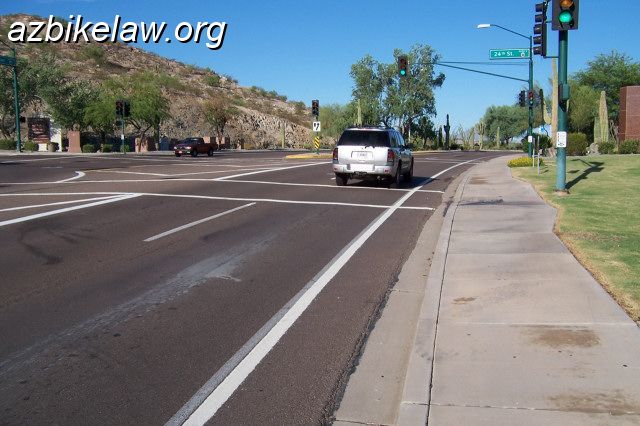


In a word, No. None of these are bike lanes. But someone sure went out of their way to make it look so. They even moved the not-bike lane stripe over to make more room in the not-bike lane (center photo). [See Fig 1, here, for a picture and description of how an actual bike lane is marked]
 What is the correct — both legal and safety — position for a cyclist to assume in these not-bike lanes? Just try to get a straight answer out of the-powers-that-be (in this case, the City of Phoenix) on that one.
The law is refreshingly clear: “If the lane…is too narrow for a bicycle and a vehicle to travel safely side by side within the lane” a cyclist may ride anywhere in that lane, §28-815(A)(4).
See other articles on critical width; see AASHTO for dimensional guidelines for (real) bike lanes.
Dimensions
Exactly how wide, or narrow as the case may be, are these ridiculous shoulders? Dimensions of the shot of the white SUV, in the top-left picture, can be found here.
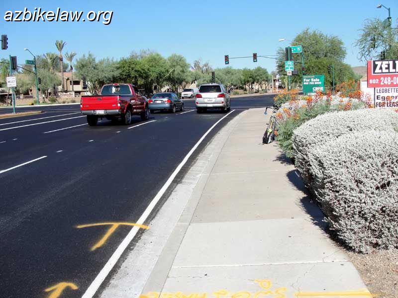
Dimension of Ray Road, the picture with the big yellow school bus are as below. This section is typical of Ray Road between approx E 3600 and 4400 blocks in Phoenix (but there are even narrower parts, as pictured above top-right):
115 / 38 / 14″ : lane / shoulder / gutter pan
The “bike lane” (were it to be one, it is not) would the be 38+14 = 52″ — 8″ shy of nominal.
But that’s not even the biggest problem. The travel lane, at less than 10′, is unusually small by Phoenix standards. The usable width is 115+38 = 153″ (less than 13′) is unsuitable for any side-by-side sharing, as is graphically obvious from the photo. This is 15″ shy of being sharable with narrow-profile motor vehicles, and a bus or truck or trailer is out of the question.
Good graphic of how 14′ usable space can be shared by a typical cyclist and a typical, narrow, motor vehicle from cyclist and traffic engineer Richard Moeur. Or even better, there’s a very cool modern interactive tool linked here from iamtraffic.org.
Cyclists riding in the shoulder can and will, I can attest to from first hand experience, get passed with just inches to spare by drivers merrily and illegally skimming by cyclists in the “not-bike lane”.
Large vehicle dimensions are commonly 8′, or 8.5′ (e.g. see Large School Bus Design Vehicle Dimensions ; the AASHTO defined SU truck or BUS is 8.5′); not including mirrors.
What the MUTCD Says (#mutcd)
The Manual of Uniform Traffic Control Devices, MUTCD, is the transportation engineer’s bible, throughout the United States; it is incorporated into Arizona law, see the-mutcd-and-a-r-s.
See sections 3B06 and 7, Edge Line Pavement Markings, and Warrants for use of Edge Line Markings. What is an edge line? “If used, edge line pavement markings shall delineate the right or left edges of a roadway”.
Types of roads where their use is warranted include “Freeways, Expressways, and RURAL arterials”. (my emphasis). Note that urban arterials are NOT on the list, to put it another way, the use of edge lines on urban arterial is non-standard and unwarranted. The only other possible allowable usage would be “where an engineering study indicates a need for edge line markings” — were there engineering studies done to support their use? I, um, highly doubt it.
The kindest thing i can think to say about edge lines (on urban arterial with closed shoulders) is they are not prohibited, due to the “if used…” language in 3B06.
Planners continue to insist these urban stripes “help”, and engineers go along with it, but is there any research to back that up? The most comprehensive source of modern research appears to be this meta-analysis Benefits of Pavement Markings: A Renewed Perspective Based on Recent and Ongoing Research, presented at the 2009 TRB meeting. The paper has an extensive bibliography and analyzes literally dozens of earlier papers going back to the 1950’s, the vast majority of which refer to use on rural highways, not urban arterials. Typical titles in the bibliography: “Impact of Edge Lines on Safety of Rural Two-Lane Highways”, or “Evaluation of Wide Edge Lines on Two-Lane Rural Roads“, or “Crashes on Main Rural Highways Related to Speed“, etc. Furthermore the supposed safety improvements, “Crash Reduction Factors” are not presented by mode, only as a single statistic. In short, there is no known research to back up this claim that it will improve bicyclist safety.
The idea that urban edge lines improves bicyclist safety appears to be nothing more than a wished-for result by those who want to encourage edge-riding (because people find it “comfortable”), even though this is both not legally required, and unanimously rejected by all traffic safety organizations, please see where to ride in the road.
Recommendations
Since motorists have an expectation that cyclists must use bike lanes; these not-bike lanes cause confusion, since they are widely perceived as actual bike lanes.
The confusion has only deleterious effects on cyclists, one of two problems arise:
- encourages (mis-informed) cyclists to ride too far to the right, this encourages motorists to buzz cyclists. Or,
- cyclists riding (legally) in the lane are harassed by motorists.
Planners should not lay out urban arterial roads with a right lane that has a “critical” width. See below for old quotes from the 1999 Guide.
Critical width is a a lane which is or appears to be wider than necessary for a vehicle to travel in; yet not wide enough to accommodate safely both a vehicle and bicycle side-by-side — about 15′ for usable width. for most vehicles (and/or vehicle / bicycle combinations; just like vehicles, different bicycles have varying widths).
…
Where these bad layouts already exist, because of the confusion caused to both cyclists and motorists, the stripe should be removed; i.e. it should have never been placed there in the first place.
If edge lines in urban settings must be used for whatever reason; the responsible agency should do both:
- install hash markings, MUTCD Section 3B.24 “Chevron and diagonal crosshatch markings may be used to discourage travel on certain paved areas, such as shoulders…”, which would allow everyone with eyes to see the space is not an intended travel lane. Bicyclists would retain the choice to travel on the shoulder.
- Install Bicycles May Use Full Lane Signs (R4-11), and the Change lanes to Pass placard if the travel lane is too narrow to share side by side (e.g. less than 14 feet per AASHTO; this is nearly always the case on urban arterial roads).
.
A Ray of Hope
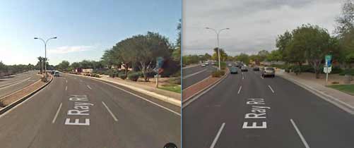
Yes, that was a little play on words — When a portion of Ray Road in Phoenix (it was the eastern-most section in city of Phx, the approx 1 mile from Ranch Circle to I-10) was rebuilt in July 2010, it overlapped with the portion that has the onerous stripe. Happily when the newly rebuilt portion was striped, the edge stripe did not make a reappearance. So the portion between Ranch Circle and 44th Street, about 1000 feet, used to look like the picture above (or you can see it in this 2008 google street view) with the school bus but now looks like this (east and west bound; the west bound has just a few feet of edge stripe in order to mate up with the bad old existing edge stripe):

It’s only maybe a quarter-mile but at least it is a step in the right direction. Here’s a before-and-after 2010 view, when the edge line was removed; as was already mentioned, this was never a bike lane.
For reference, as close as I can measure with google maps; there is about 34′ from curb-to-curb. This is an unfortunate amount of space for those who want there to be BLs here. Shoehorning is the only way to get a BL and maintain 3 through travel lanes; something I don’t want to see, because it can’t provide enough passing clearance for many vehicles.
Updates
I see it’s been over 5 years since I saw a ray of hope. Unfortunately nothing additionally has changed — Most of Ray Road continues to have an (as far as I can tell) unwarranted edge line.
Here’s a brief discussion thread on edge lines at cyclists are drivers! f.b. group.
ADOT
ADOT rarely designates bike lanes; whether designated or not, there a dimensional problem because they prefer to set aside 16′ of space on urban designs including a two-foot wide gutter pan. This leaves an unfortunate amount of space that is difficult for bicyclists to deal with, perhaps especially when they indulge in using unwarranted edge lines; since that leaves a 12′ lane next to only 2 usable feet of what appears to be a bike lane…
ADOT Roadway Design Guidelines 2012 Edition (which appears to be current with the most recent, 2014, updates and revisions —
Page 300-11, section 302.4 — Shoulder Width, Table 302.4: Urban multi-lane divided or undivided 5 or more lanes, (what about Urban undivided 2-lane?), or Frontage Roads (2-lane) One or Two way: The right shoulder width for all of these is 4 feet
And note 2 states “For shoulders with curb and gutter, widths include gutter pan”. (ADOT gutter pans are two feet wide, by the way).
Page 300-48 Urban Highway Typical Sections, Figure 306.4A
Contains diagrams for 3 typical sections, UA UB and UC:
Sections UA and UB (curb-and-gutter) has a 16′ from lane line to curbface, along with the notation:
Consider 17 ft. on a project by project basis to accommodate bicyclists. Consider factors such as location , vehicular traffic, grades, anticipated bicycle usage and right of way availability.
Section UC (no curb-and-gutter) is shown with a 12′ right lane, then 4′ of something (presumably shoulder, presumably with an edge line?), then 8′ of sloped away space.
So here’s where we get these ADOT fake bike lanes, on e.g. Price Frontage road: a 12′ right lane with an edge line enclosing a 4′ shoulder which includes a two-foot wide gutter pan.
You should really go check out the brand new designed bike lanes at Indian School.
Do we design travel lanes substandard? Why is it every bike lane is substandard? A bike lane is suppose to be 5 feet. So that you can position yourself 3 feet from traffic.
here is a brief statement, posed as a query. I thought it was particularly concisely stated:
“do restriping plans show bike lanes or edge lines that not would meet minimum width of 5 feet from face of curb to lane stripe with at least 3 feet of ridable surface excluding gutter pan per AASHTO Guide (pp. 23 & 24)? If anything less than this minimum is to be provided, then I request that no edge line be striped since some bicyclists and some motorists interpret that narrow space to be where bicyclists belong, which can encourage unsafe passing.”
See more/newer article about vehicle width.
The AASHTO SU Single Unit Truck and Single Unit Bus Width
info was moved there.
Is it legal to use a Bike Lane, to make a right hand turn at an intersection?
Reducing lane width is theoretically reduces MV speeds, however as they put it in ITE Traffic Calming: State of the Practice (1999), p.122 “The theory is not borne out by empirical studies”. (how does this square with NACTO’s claims?)
THIS INFO IS VERY OLD, AS THE DRAFT WAS SUPERCEDED BY THE 2012 (4th) EDITION. See here for sharable width quote.
Planners should not lay out urban arterial roads with a right lane that has a “critical” width. This is a critically important revision needed to the current (1999) edition of AASHTO’s Guide for the Development of Bicycle Facilities: “an outside or curb lane wider than 3.6 m (12 feet) can better accommodate both bicycles and motor vehicles in the same lane and thus is beneficial to both bicyclists and motorists (p.17)”
Improved wording in the DRAFT Guide reads: “Lane widths of 13 feet (4.0 m) or less require most motor vehicles to be driven at least part way into the next lane to pass a bicyclist with an adequate and comfortable clearance (usually 3 ft [0.9 m] or more depending on the speed of the passing vehicle). Lane widths of 14 feet (4.3 m) or greater enable motorists to pass bicycles [sic] without encroaching into the adjacent lane” (p. 57).
In 2016; I made a somewhat formal request to the City of Phoenix about the edgelines:
https://drive.google.com/open?id=1rq5nmVSydJ3OcUOnziNZy1ehEK2BUzIH
This was the response, along with my initial response to that response:
https://drive.google.com/open?id=1_edEB_C9KxPPVxDaxAt6egl-MtNYLZTV
There was follow-up by phone with the engineer. He clarified to me that he considers the email he sent to me an “Engineering Study”.
I think that’s ridiculous but there you have it.
I should clarify that I don’t claim the edgelines are non-compliant (or not allowed, or illegal or however you want to phrase it) by the MUTCD. Only that they are in fact not warranted (and by the way, BAD for bicyclists when misused in this way). That email doesn’t constitute a legitimate engineering study.
Fast forward to 2019 — many if not all of the edge-lined areas along Ray and Chandler Blvd have been resurfaced (either mill/overlay or microseal) and subsequently have been restriped precisely has they had been.
Curiously around the same time another segment which formerly was two thru lanes with no edgelines was restriped to have a narrow designated BL next to a very narrow lane; see https://azbikelaw.org/shoehorn-bike-lanes/ and scroll to Mountain Parkway
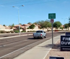
In early 2020; BMUFL signs have appeared along some of the edgelined sections.