Bicyclist killed in crash on Tucson’s northside

super high speed merge ramp / Pima County

Read the deets on bicycletucson.com

1/24/2016 11:45am Tucson-area (Pima County Sheriff’s dept investigates).

A (somewhat elderly, coincidentally) female bicyclist traveling west on Sunrise Drive was killed by a very elderly motorist who was merging from Skyline Drive and apparently failed to yield. The bicyclists was later identified as 69 y.o. Patricia Lyon-Surrey. Continue reading “Bicyclist killed in crash on Tucson’s northside”

Injured bicyclist files $13.5M claim against Pima County

photo: Mike Christy / Arizona Daily Star

This involves a odd “crossover” type situation with a dedicated right turn only lane at the ‘T’ intersection of Sabino Canyon and Kolb, in Pima County. I’ve looked at the google street view (not sure if that matches the way it was at the time of the Jan 2015 crash); anyway, it’s confusing. There are two northbound bike lanes (or are they “bike routes with striped shoulders? — see that background at the article about a cyclist seriously injured at the Dodge Bridge in Pima County who received a $1.8M settlement with the county).

Continue reading “Injured bicyclist files $13.5M claim against Pima County”

Dodge Blvd Bridge and sub-standard Pima Co bike facilites

First off — never ride too close to the edge of the road; you are more likely to run into problems there including debris, bad road surface conditions or other obstructions like drainage grates and so forth.  See where to ride on the road for more.

Pima County / Tucson does not have “Bike Lanes”, they, if asked, insist there are no bike lanes, but rather they are “Bike Routes with Striped Shoulders“. Though of course they (everyone, including Pima County’s press releases ) refer to these odd bike facilities as bike lanes whenever convenient — e.g. “The bike lanes on the Dodge Boulevard Bridge over the Rillito River will be closed for drainage modifications, starting at 5 p.m. Wednesday, July 3, 2013. Bicyclists are asked to seek an alternate route.” [Some updates; as of Jan 2015 I just noticed there are two different bikeway maps covering Pima county, one put out by pima co DOT, at pima.gov and another put out by PAG (Pima Assoc of Gov’ts) the PAG map marks almost everything in blue, including this hot mess, which according to the key is a “Bike Lane”. The PCDOT map is the one that still refers to the bike route with striped shoulders, using the red key color]

Now there’s this… this is a real abomination:

BadBikeFacilityDodgeBlvd

(I’m not sure if this reflects what is there now, or rather what was there at the time of this bad crash) Here’s a google maps street view of the Dodge Blvd bridge over the Rillito near Tucson (apparently it’s owned by Pima County). There is some sort of weird 2′ wide band of green (paint, i guess?) directly next to the curb — from what i gather the gap referred to below is between the curb and the green paint. The google street view coincidentally caught a cyclist dutifully riding within that very narrow band of green paint, just inches from the “drainage gap”. Continue reading “Dodge Blvd Bridge and sub-standard Pima Co bike facilites”

[civil suit finally settled] Rumsey guilty of manslaughter

[ UPDATE May 2012: Final awards in Jose Rincon’s civil lawsuit after a trip to appellate court; azstarnet.com (though their links seem to regularly go dead). Note that the original award of $13 was the LARGEST judgement ever against the city:

…Chuy’s settled before the February 2010 civil trial for an undisclosed sum. During the trial, jurors were told that a city engineer had abandoned plans to add five feet of asphalt to the roadway during an improvement project, creating a large offset in the lanes on either side of Vozack Lane, just east of Harrison. As a result, Rumsey ended up in the bike lane when her lane ended and she tried to merge.

The jury decided Rumsey, the city of Tucson and Chuy’s were equally responsible and awarded $40 million to the Rincon family. The city’s $13 million share was the largest individual judgment ever against the city. The city appealed, and Pima County Superior Court Judge Kenneth Lee denied the motion for a new trial but granted the defendants’ request for a reduced judgment, slashing the judgment to $12 million.

The city then went to the Arizona Court of Appeals, and it decided in March 2011 that the case should be retried. The Rincons settled with both Rumsey and the city recently.

The settlement with Rumsey is confidential; the settlement with the city specifically states the city was making “no admission of liability, culpability or fault, either by expression or implication.” …. Back when Lee reduced the $40 million judgment, Rincon said he and his wife had agreed to settle the lawsuit for $950,000 before trial, but the city refused. He bemoaned the fact that because the public didn’t know the city hadn’t accepted the settlement offer, residents were under the impression he and his wife were “money-grubbers.”…

The city’s appeal is online at justia.com RINCON v. RUMSEY, CITY OF TUCSON, contains some interesting stuff. (it should also be online via court-of-appeals div 2 website, but i haven’t looked for it there). Note that the superior-court appeal upheld the trial judge; while the court of appeals found the trial court judge (and thus the superior court appeals judge) erred.

]

Glenda Rumsey was found guilty of manslaughter in the death of Tucson teenager Jose Rincon.  (see here for a roundup of types of murder). Like many drunk drivers, she also tried to run. Continue reading “[civil suit finally settled] Rumsey guilty of manslaughter”

Bike Facilities Maps

Maricopa County / Phoenix area

I had a hard time finding this, so here it is

It’s maintained by MAG’s (Maricopa Assoc of Gov’ts) Active Transportation Committee (formerly the Bicycle and Pedestrian Committee) and note that the MAG region includes not only Maricopa, but also portions of Pinal and Gila counties. There is a pretty neet online version that overlays google maps, or an old-school .pdf download (it’s pretty big)., and another version that has something to do with mobile/gps.

Alternately, Maricopa County DOT (“McDOT”) has an active transportation plan along with an interactive map that is built from the same database as above, but in this version, users can leave comments about specific areas of concern for bicycling / walking.

There is also a printed City of Tempe published map I’ve seen floating around; not sure if it’s online.

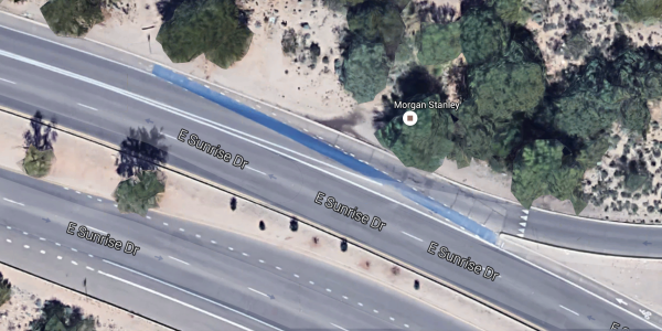
On the MAG interactive map, designated bike lanes are clearly labeled (they’re ‘blue’); and are distinct from other sorts of not-bike lanes, e.g. bike routes.

Pima County / Tucson area

There are two i know of; perhaps/presumably based on the same data. One is published apparently by the Pima County Dept of Transportation. Currently linked here at the Pima county bicycle and Pedestrian Program. There are several links there, e.g. current link to page1 Tucson area.

This map suffers from far too much ‘red’ which the key says:

Bike Route with Striped Shoulder, Bus/Bike Lanes
On major street, with white-edge line, approx. 4 ft. to 10 ft.
wide paved shoulder, with speed limits of 25 mph or more.
Includes Bus/Bike Lanes on major streets, 10-12 ft. bus and right-turn lane, shared use with bicycles.

Virtually every major road throughout the region is ‘red’. Are these designated bike lanes, or not? (a bike lane is part of the roadway, a shoulder is not). What is frustrating is the answer seems to depend on when (it seems to evolve over time) and who asks the question, and who is answering.

There is a second map, covering the same territory, at pagregion.org. and current link to .pdf. Here we see virtually all major streets (the same streets, by the way) are ‘blue’ which the key says are “Bike Lane”.  Really? Are these really all designated bike lanes? Are they wide enough to be bike lanes? E.g. The Dodge Bridge is in ‘blue’.

Flagstaff

City of Flagstaff bike map page.Major streets are all marked in ‘purple’ , which the key says is

Bike Lane or Shoulder: An outside lane of four to five feet in width for the exclusive use of bicycles, separated from vehicular lanes by a white stripe. This definition include bike lanes designated by signing and pavement markings, as well as paved shoulders delineated by a stripe, but not pavement markings or signing.

So there’s no way to tell from the map what is a Bike Lane and what is a shoulder. Nice. And by the way, Flagstaff,  shoulders are not lanes.

As far as i can tell, there’s not really a Coconino county bikeways map.

Summary

MAG (Maricopa) Bikeways map is honest. The maps for Tuscon, Pima, PAGregion, and Flagstaff are at best non-informative and at worst dishonest.