[updates, see warner-resurfacing for changes made in late 2016]
This article is to document the problems with the designated bike lane on Warner Road specifically at the intersection with Kyrene in the City of Tempe. Remember, there’s literally no excuse for bad bike lanes; if you can’t build them properly, then don’t build them.
For Warner Road more generally, see should-warner-road-bike-lane-have-a-combined-turn-lane. Warner Road is a major east-west arterial street with two through lanes in each direction, a center turn lane, and designated bike lanes. It is posted 45mph; there is very little speed enforcement, in fact I’ve never seen any speed enforcement. The bike lane frequently is dropped at major intersections, including the eastbound bike lane at this intersection.
The below text was submitted to Tempe311 on 1/6/2015 as a Streets/pothole issue (that’s the closest category I can see) It is case ID 292707:
This is a Streets Engineering (mostly) issue. I would strongly encourage you to view http://azbikelaw.org/warner-and-kyrene/ as I can’t figure out how to attach photos to the 311 request.

To begin with, I should point out that Warner Road at Kyrene is WIDER than normal (compared to, say Warner’s intersections at Hardy, Rural, or McClintock — the other major nearby cross-streets). It is unclear why, but this coupled with bad / improper / substandard engineering (and a maintenance issue) has made things WORSE for cyclists; every one of the four possibilities has problems, which I’ll list from the most serious to least:
-

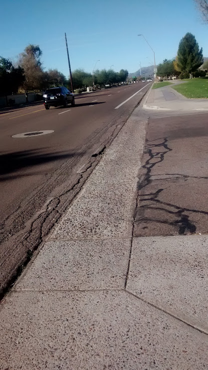
Bad bike lane / Warner Road, Tempe Problem #1) Eastbound, east of Kyrene: beginning around 300′ east of the intersection, the bike lane is severely substandard width of only about 2 feet. This has to do with a poor design of right-turn pocket. It is exacerbated by a bad asphalt job that left the asphalt as much as 2″ higher than the flat concrete gutter. This was further made worse by an attempt to correct the height disparity in Aug 2014 by grinding which has left what you see in the picture at right. Here is a longer-view pic of the problem.
- Problem #2) Westbound, west of Kyrene: beginning at the intersection, and continuing for ~ 300′ the bike lane is substandard width. I am routinely harassed when riding in the right-hand lane though this area.
- Problem # 3) Eastbound, west of Kyrene: there is a “pinch point” in the bike lane (in other words, it’s substandard width but only for a short distance) ~ 300′ west of the intersection.
- Problem #4) Westbound, east of Kyrene: the bike lane ends about 400′ before the intersection. Although I would normally recommend re-striping as a combined turn lane; that would be highly inappropriate because of problem #2. This road is posted 45mph, the City of Tempe’s design forces bicyclists to merge with very high speed traffic (or many cyclists choose to illegally continue straight through the right turn only lane). Road design should support both legal and safe use by all road users.

The substandard-widths are so obvious, they can be readily seen from google maps satellite images — note that the bike lane markings logo is 40″ wide. Minimal bike lane requires 48″ of clear, consistent, usable surface (see e.g. AASHTO).
If any of these facilities are, in fact, not bike lane stripes but are rather, edge lines — please provide a warrant for their use (or remove them). Edge lines are unwarranted per MUTCD 3B.07 on city streets unless indicated by and engineering study. If an engineering study has been performed there please let me know where I can get a copy.
Also related to the engineering challenges, is Warner Road apparently changes alignment at Kyrene; it is, for example further north on the east side of the intersection, and further south on the west. I don’t know why this is but it shouldn’t be an excuse to create poor dedicated bicycle facilities.
I can also point out that the bad/sloppy asphalt job along with bad conditions at the junction of the asphalt and gutter seam persists for most of the entire mile on Warner between Kyrene and Rural. For example see pic of Warner at Dateland Dr: Sloppy asphalt / grinding / deterioration of asphalt at gutter seam.
Just some updates August 2016
(This update relates to what was referred to as Problem #1, above. There’s been no changes with the other 3 issues)… I have been complaining, er, bring these deficiencies and defects to the attention of the City of Tempe for some years now. Most recently, in Dec 2016, I was told “Warner Rd is planned for pavement resurfacing and could start as early as Fall 2016. Traffic Engineering will redesign the striping to fix known issues/concerns (especially at Warner & Kyrene) that have been identified. Thanks for sending this and it will be part of the redesign of the street”
Unsurprisingly, the condition of the asphalt in the designated bike lane on Warner Rd, Tempe, continues to deteriorate; as always, the worst is eastbound east of Kyrene. The deterioration may have been accelerated due to the (ill-advised, in my opinion, for what it’s worth) grinding done ~ August 2014.

Comment on the three cyclists, that was an un-staged photo; those guys just so happened to show up while I was taking pictures. It’s obvious, understandable, and correct that they would not ride within the BL. What’s maybe less obvious is why they shouldn’t ride where they are riding; trying to straddle the two lanes. Everything works fine most of the time, if you’re lucky, overtaking vehicles squeeze left and whizz by unimpeded. If you’re unlucky, you get a close pass; or worse.
It’s also presumptively illegal — all drivers (and bicyclists) must drive (ride) ” as nearly as practicable entirely within a single lane” §28-729. Would you get ticketed? Almost certainly not; but in the event of a collision, and this position exacerbates a sideswipe possibility, you can expect an insurance company to bring it up.
November 2016 / mill & overlay
In a surprise (to me), the city of Tempe is resurfacing (“mill & overlay”, a.k.a. “mill and fill”) Warner from I-10 to Dateland drive… this material was moved here.
tempe311 submitted on account EBEIGHE. Case ID / access code: 292707 / 773110.
Responses (so far anyway):
01/07/15 09:04:35 AM Case reassigned to Traffic Engineering. Also, Warner btwn I-10 and Rural will be redone with FY 16/17 funds.
01/07/15 08:21:14 AM Called out to 257.
I’m guessing “257” means street maintenance of some sort.
It was also marked “Closed” at 9:05am so I’m not exactly sure if I should expect further response; i supposed I’ll wait and see.
Case ID: 526655, Case Access Code: 447940 —
Background: please refer to Case Id 292707, Jan 2015.
Nothing was resolved, however at that time the reply said “…Also, Warner btwn I-10 and Rural will be redone with FY 16/17 funds”, and was told more recently this could be as soon as fall 2016. Which I took to mean that since Warner was scheduled in the near future to be redone; it was okay that this section was bad.
I have recently been told that the re-doing of Warner would be no sooner than after FY 18/19.
So, I will bring this to your attention again, hoping for some progress this time:
The designated Bike Lane on Warner Road eastbound, east of Kyrene: beginning around 300′ east of the intersection, the bike lane is severely substandard usable width of only about 2 feet. This has to do with a poor design of right-turn pocket. It is exacerbated by a bad asphalt job some years ago that left the asphalt as much as 2″ higher than the flat concrete gutter. This was further made worse by an attempt to correct the height disparity in Aug 2014 by grinding which has left what you see in the attached picture; the limited space left in the bike lane is seriously degraded and falling apart.
Bike lanes should provide no less than 4′ of usable space, see e.g. AASHTO 2012 Guide for Development of Bicycle Facilities. Providing at least 4′ there would require an engineering correction, however you could certainly maintain the existing asphalt.
I have attached a current picture of the area to this case.
There are more details and more photos here: http://azbikelaw.org/warner
————————————————————–
Case ID: 526657 Case Access Code: 171325 —
Background: please refer to Case Id 292707, Jan 2015.
Nothing was resolved, however at that time the reply said “…Also, Warner btwn I-10 and Rural will be redone with FY 16/17 funds”, and was told more recently this could be as soon as fall 2016. Which I took to mean that since Warner was scheduled in the near future to be redone; it was okay that this section was bad.
The Warner Road designated bicycle lane westbound, just west of Kyrene: beginning at the intersection, and continuing for ~ 300′ the bike lane is substandard width. I am routinely harassed when riding in the right-hand lane though this area.
Bike lanes should provide no less than 4′ of usable space measured from the gutter seam to the stripe, see e.g. AASHTO 2012 Guide for Development of Bicycle Facilities. Providing at least 4′ there would require an engineering correction BUT THERE IS PLENTY OF WIDTH IN THE RIGHT-OF-WAY THERE.
In the meantime, you should obliterate the stripe (either the BL stripe or the edge line stripe — whatever you want to call it). If you are claiming it is an edge-line in this section (and not a BL stripe) and insisting on keeping it there, you should add hash markings, MUTCD Section 3B.24 “Chevron and diagonal crosshatch markings may be used to discourage travel on certain paved areas, such as shoulders…” to visually reinforce that this is not a BL, which will also help drivers “shift” (Warner Road’s alignment shifts left several feet at the intersection for drivers going westbound)
There are more details and more photos here: http://azbikelaw.org/warner
place 10/6
Segment on Warner Rd from the I-10 bridge deck to Jewel Drive; this is about 1,000 feet.
This segment does not have a BL, it did not have one before the late 2016 resurfacing, nor after. Exactly why the BL begins/ends at Jewel isn’t clear, it probably has something to do with ADOT and Tempe.
DISCLAIMER: all widths mentioned below are estimates based on visual guesses, and measuring with Google Maps.
Regardless.
SIDENOTE: I prefer crossing I-10, and I cross I-10 a LOT, at Warner, compared to e.g. Ray or Elliot. Crossing at Chandler Blvd, or Guadalupe aren’t bad, either, but that typically takes me more out of my way; i live between Ray and Warner.
Conditions for bicyclists crossing I-10 vary dramatically whether they are eastbound or westbound. Because I-10, there anyway, is built at-grade, users wishing to cross it are inconvenienced by having to ascend/descend.
There are two through lanes in both directions, and as mentioned above, no bike lanes on either the Phoenix (west) side, the bridge deck itself, or the Tempe (west) side.
Eastbound: Beginning from the Phoenix-side, cyclists should ride in, and “control”, the right lane — there is no additional special right-turn / entrance lane to cause any confusion. This is quite easy to do, as the lane is a good compact size, probably 11 feet. The compact lane continues on the bridge deck; and again is easy to “control”. Some cyclists will filter forward. Don’t do it; there’s not enough width.
On the east side of the bridge is where conditions change — though there are no bike lanes, there is apparently enough space to make a well-proportioned BL while keeping two through general-purpose lanes; there appears to be 28′ available in total for the eastbound lanes. This is currently divided up something like 12 / 14 / 2 (left lane / right lane / gutter pan). It could readily be re-proportioned as 11 / 11 / 4+2 (left lane, right lane, 4 foot BL plus a 2 foot gutter).
Since this is downhill, cyclist might be traveling quite fast; in the current configuration of 14′ of usable width, sharing side-by-side is dicey and uncomfortable; and alternately attempting to “control” 14 feet is difficult.
The additional (added circa 2010 when the Drury Inn and Carl’s Jr was built?) right turn only lane at Jewel is unfortunate, by which I mean it creates another high-speed merging conflict zone, when there was already a full-blown right turn only pocket at Emerald/Harl, only 500 feet away. In any event, that doesn’t change the geometry, it seems there is still 28′ available for through traffic in addition to a perhaps 12′ RTOL.
The existing BL eastbound then begins just beyond Jewel St.
Westbound: Has a whole different set of issues. The existing BL simply ends at Jewell; at which point there are now, briefly, THREE general purpose through lanes. A bicyclist is going to end up on the right side of the right-most lane which is for the moment wide. That lane quickly tapers to narrow, and then turns into a RTOL; at the same time it’s ascending, meaning a bicyclist might only be going 10mph. Depending on the volume of traffic, a difficult merge is required to get from the third lane into the next lane over (the right-hand of two through lanes) to cross the bridge.
Crossing the bridge then, and continuing/descending into Phoenix is readily done by controlling the right lane which is a good, compact size of about 11 feet.