 I have a lot of thoughts about this stretch of roadway in Phoenix: 48th Street (turns into Guadalupe Rd), north of Piedmont. [google maps]
It involves the odd geographic position of the Ahwatukee area of Phoenix; and the the almost complete lack of connectivity for Ahwatukee residents to anywhere else, (Tempe, Chandler, and indeed the main portion of Phoenix) except by car-choked umteen lane roads.
Ahwatukee is called — sometimes derisively, sometimes happily — the world’s largest cul-de-sac. Setting aside 48th street for a moment; Ahwatukee’s ONLY ingress/egress is Pecos Rd (which is loop 202, a limited-access highway), Chandler Blvd (10 lanes?), Ray Road (10 lanes), Warner Road (only 6 lanes?), Elliot Road (10 lanes?). So these are all either a limited-access freeway, or humongous monstrosities that have interchanges with I-10.
In short, these are all car-choked, car-sewers. They are not particularly bad for cyclists; two (Ray, and Chandler) have wide-curb lanes; Warner has nice narrow lanes; I find Elliot road to be most annoying as it is “critical width“; that is to say not wide yet not narrow enough to be perceived as too narrow to share by many motorists. Yet many cyclists, understandably, don’t want to do it. It is a thoroughly obnoxious experience for pedestrians, too.

48th Street/Guadalupe is the ONLY bridge over I-10 that is a reasonable human scale, it is 2-lanes (only 1 in each direction!), and has no interchange with the freeway, it’s just a bridge. Thus this makes a vital connection for anyone wishing to bike between Ahwatukee and, say, Tempe/ASU. And it also forms the ONLY connection for Ahawatukee bicyclists wishing to get to the rest of Phoenix (through The Pointe at South Mountain, now called ???. Using what are actually private streets but there’s some sort of public easement).
Why are there no other non-interchange bridges over I-10? E.g. in Tempe, Hardy Dr crosses US60; and there is a ped-bridge just a mile or two away at College. Ahwatukee is like 5 miles. Why don’t ANY collector roads, e.g. Knox Road, cross I-10?
Back to the present case
Here are a bunch of captioned pictures: azbikelaw.org/images/48thGuad
So this stretch of 48th street has been a continuous bone-of-contention for years. North of Piedmont, the road consists of two no-questions-about-it narrow lanes (perhaps 11 feet, excluding gutter pans) in each direction. The posted speed limit is 35mph. There is no shoulder (only an odd edge line just to the left of the gutter-pan joint on the northern half — this was removed after the resurfacing done in fall 2013). There is a raised median; the median appears to be approx 18 feet (curbface-to-curbface) wide.
Let’s be very clear: cyclists may (legally) and should (for safety) be riding IN THE MIDDLE OF THE (right) LANE when going straight ahead.
It appears the best thing the city could do would be to install Shared Lane Markings (SLM, a.k.a. “Sharrows”). The standard calls for “the centers of the Shared Lane Markings should be at least 4 feet from the face of the curb”… in my opinion placing them at the minimum 4′ is confusing far to the right in an 11′ lane (who came up with that spec?). The gutter pan is about 1 foot, perhaps a little more — I would want to see the center of the marking to be something like 6′ from curbface.
For extra credit, I would also like to see some BMUFL signs (see same link above as Shared Lane Markings).
Bikes May Use Full Lane Signs
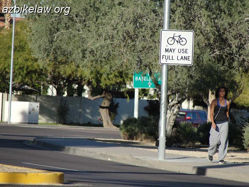 As of 1/5/2012 the BMUFL (R4-11) signs are in place; it looks like there are six of them. I think these signs are great — that is, unlike a “share the road” sign, they have less chance of being mis-interpreted. I was a little surprised at how many cyclists I saw just in 15 minutes while taking pictures. I noted 5 cyclists total not counting myself: 3 southbound ( #1 shows a motorist waiting to turn right , #2: showing some good motorist passing examples, and #3: a gutter bunny where motorists don’t change lanes to pass), one northbound, and one northbound conterflow on the sidewalk. Given the time of day, 4pm, the predominant traffic flow was southbound as expected.
I do have a gripe with the signs, at least two of them are heavily obscured by other signs, and thus are less likely to be seen by motorists. I have no idea how easy it is to address this problem, in one case some of the obstruction is from tree branches which seems simple enough to fix. In other cases, it may be that there are just too many (other) signs.. dunno.
This one is obscured by some tree branches and the “welcome to Phoenix” sign. I took this from the median, the view from where a driver would be is far more obstructed. Could the BMUFL sign be hung on the same post as the welcome sign? — that would make it a lot more visible. Another is obscured by a really big directional sign. Not sure what the solution is, the road curvature is a problem.
Sharrows Appear

[update 1/17/2012. There is an email from city engineer Kerry Wilcoxon explaining more about the situation and plan for fix/finishing here. In paraphrase, the city is having some delay/difficulty procuring thermoplastic SLM’s — once they do, they with fix the bad ones and apply correctly in thermo all along the whole stretch; but there is not timeframe given. (this never came to pass, read on…]
[updated ~ Feb or March 2012; well, the sharrows that were painted have been blacked out and moved to the center of the lane. Yay! We are still awaiting (any) sharrows on the rest of the project… they remain missing as of March 2013. Here is a photo of the original sharrow placement that has since been moved to the center of the lane.]
 [updated 11/20/2013: the “northern” section was (finally) re-surfaced (“overlay”, i think they call it) sometime in fall of 2013 and the SLMs were finally installed today pic1 pic2 pic3. Oddly, the thermoplastic stencils, mentioned above, were not ever used.]
One consistently odd thing is the symbol used by the city of Phoenix is not the one specified by the MUTCD, figure 9C.09 , see graphic at right compared to the photos… this means the symbol is an “illegal” traffic control device, as it does not appear in the MUTCD or AZ supplement. The MUTCD part 9 FAQs even caution specifically to not use the “helmeted bicyclist” symbol:
Q: Can I use the Helmeted Bicyclist Symbol pavement marking in lieu of the conventional Bicycle Symbol pavement marking for incorporation into the Shared Lane Marking shown in Figure 9C-9?
A: The Helmeted Bicyclist Symbol pavement marking (see Drawing B in Figure 9C-3) may be used for the Bike Lane Marking. However, for uniformity the conventional Bike Symbol pavement marking (see Drawing A in Figure 9C-3) as shown in Figure 9C-9 should be used for all Shared Lane Markings because that was the symbol tested during the experimental stages that yielded the best result.
Sharrows Refreshed
The city refreshed paint on the sharrows in early May 2016. (I think for the first time?). They were pretty faint.
The Private Section of 48th Street.
for no reason other than it’s close to where 48th Street and Guadalupe Road split…. The section near 48th Street, Point Parkway East, through what used to be called the Pointe at South Mountain resort is a private street since it was built in the 1970s. A public easment was maintained but was apparently always under threat of closure. This would leave Ahwatukee completely disconnected for the main part of the City (except for the freeway; or to detour over to Tempe, and back to Phoenix). in 2016 a deal was struck to make it public. It involves Charles Schwab for some reason.
City strikes deal with business association to bring road security, jobs to area
…A significant portion of 48th Street, between the Point Parkway West traffic circle and Baseline Road, had been operated as a private road since its construction in the 1970s, and it was a portion of the road that constantly, if quietly, faced the threat of closure. However, on Jan. 6 the Phoenix City Council voted unanimously to pass a development agreement that would finally make the road a fully public street owned by the city by mid-2018. . . . The city has allocated $500,000 for maintenance of the road over the next several years, funding that will come from the Street Transportation Department’s Capital Improvement Plan budget…
if CoP wishes to add bicycle facilities, they should consider shared lane markings (and maybe BMUFL signs) for the downhill section to East Beverly Road instead of bike lanes (BLs would be OK for uphill) per AASHTO Bike Guide, 4.6.2., p. 4-12 (2012 edition). During peak traffic, downhill bicyclists operate at speeds close to the posted 25 mph maximum speed limit.
Some Related updates #2022
CoP did a “spray job” (I believe it was PMRE?) on the section of 48th street sometime around late 2021, or maybe early 2022; it took them awhile (and possibly because of prodding) but the SLM’s were covered over for quite some time; they did come back and re-paint them. At the time I also think i remember noticing that one (?) of the BMUFL signs is missing, but now I don’t recall.
PMRE (polymer modified rejuvenating emulsion) is a thin coating applied to the road to rejuvenate the surface, protecting it from deterioration by sun and water.
It is very good for the pavement, but is not thick enough to smooth out the slight bumps created by the crack seal.
As of May 2022, ADOT is deep into the I-10/Broadway curve widening project; this relates to the bridge re-do (widening?) over I-10 at Guadalupe… I have a message out to ADOT which was forwarded to the Broadway curve team info@i10broadwaycurve.com regarding their plans, in particular striping. They told me on May 9 they didn’t know (?) and I should check back in “late 2022”.
Guadalupe, over I-10. This is part of the Broadway Curve mega-project. I have been after ADOT since at least 2014 to get rid of bad edgelines here; they lied to me back then. This temporary project amount to a de facto cycle track https://t.co/s6Ey07b8sR pic.twitter.com/YN17Mgai6B
— Az Bikelaw (@azbikelaw) May 18, 2022
.
Here’s an email from the deep-history file, over 6 years ago!, about this stretch of road…
From: “Michael Sanders”,,,,
To: “Bob Beane (E-mail)”
“Chris Sargent (E-mail)” “Ed Beighe (E-mail)”
“Jay Stewart (E-mail)”
“Jeremy Longstreet (E-mail)” “Radar Matt (E-mail)”
Cc: “Coalition of Arizona Bicyclists (E-mail)”
“Radar Matt (E-mail 2)”
“Rich Rumer (E-mail)”
X-OriginalArrivalTime: 03 Jun 2005 19:31:16.0695 (UTC) FILETIME=[CF82E670:01C56872]
X-HotPOP-Delivered-To: ebeighe@hotpop.com
In case you missed it this morning, here’s the article that resulted =
from the meeting with Phoenix PD on May 26 in Ahwatukee:
Doggone potholes=20
Cyclists would like lane added at 48th Street, Piedmont Road=20
Ty Young
The Arizona Republic
Jun. 3, 2005 12:00 AM=20
Ahwatukee Foothills bicyclists are facing a difficult situation while =
traversing a busy local intersection.
Always interesting to read what a non-cyclist newspaper reporter picks up on at these types of meetings and what the headline writer comes up with! I didn’t come away form the meeting thinking, “yeah, those doggone potholes are a big problem in Ahwatukee.” Meeting was about sharing the road — legally and safely. And, of course, the City does not prohibit bicyclists on sidewalks (competent cyclists know it’s just not safe to use them). In fact, City Code states, “Whenever any person is riding a bicycle upon a sidewalk he shall yield the right-of-way to any pedestrian.” (Sec. 36-113).
Mike
Michael N. Sanders, Senior Transportation Planner
Bicycle and Pedestrian Coordinator
http://www.azbikeped.org/
Press Release from Phoenix Political Pedal Power (P4)
January 3, 2012, For immediate release
Phoenix Political Pedal Power strongly appreciates that the City of Phoenix has begun to use Shared Lane Markers (SLM, aka Sharrows) for increasing cycling safety when street configurations warrant them. The first use is on 48th St approaching Guadalupe Rd. where the right-most traffic lane is too narrow to be shared by a cyclist and motorist at the same time.
The presence of a Sharrow has meaning to motorist and cyclist alike. To the motorists, it means that cyclists may be using the whole lane in compliance with State Law, ARS 28-815.A.4. To the cyclist, it indicates the safest position relative to the configuration of the road and is a discouragement to motorists trying to squeak by when there is insufficient room for a safe passing.
We hope motorists and cyclists alike will continue to Share the Road in this new configuration. In this case, Arizona Law provides for the cyclist to use the whole lane when it “is too narrow for a bicycle and a vehicle to travel safely side by side within the lane”. Sharrows have been used in other Cities and States for a few years and the results have been better for all users of the roads.
See P4 on FaceBook at http://www.tinyurl.com/p4bike. P4 functions as the political action arm of Arizona Bicycle Club (ABC), a 501(C)4 organization advocating save and effective cycling, and organizes many rides for all abilities and skill levels. ABC is a member of the League of American Bicyclists which provides education by certified instructors in cycling safety and ratings of the cycling friendliness of communities, States and businesses.
For information, call Gene Holmerud, LCI #1193 at 602.243.6136 or 602.390.5344
###
I took a few pics and will copy Joe
Joe,
when can we get the paint on the sharrows refreshed (And/or replaced with thermoplastic) ? Many are nearly invisible.
Also, I noted one of the BMUFL signs that has been rotated significantly (that is, making it less visible to motorists).
Mike noted a spray-painted BUMFL
pics: 48th / Guadalupe Share Lane Markings
From: Mike S
To: RS Matt
Cc: Ed Beighe ; Lisa Cozzetti
Sent: Thursday, July 3, 2014 8:41 PM
Subject: Re: 48th Street support group
I notified JP on May Day about the faded SLM’s and the vandalized (spray-painted) BMUFL sign on west bound Guadalupe just past the I-10 bridge. No reply.
And there was no educational campaign (like City has done with pedestrian hybrid beacons). City of St. Augustine example here – “FDOT Implementing Sharrows in North Florida”
On Jul 3, 2014, at 6:17 PM, RS Matt wrote:
They are worn to invisibility. The thermoplastic units needed be installed.
—
we need to start a 48th street support group 🙂
i know Mike S uses it regularly.
I wonder if Radar has any thoughts on the sharrows?
From: Lisa Cozzetti
To: ‘Ed Beighe’
Sent: Wednesday, July 2, 2014 8:15 PM
Don agrees with you about bikes not taking the lane. He says he is the only one he has ever seen. He also thinks the sharrows don’t really stand out. He likes the signs about bikes may take the full lane but thinks there needs to be more of them.
Regarding the sidewalk, yes only when the traffic is gridlocked.
From: Ed Beighe
Sent: Wednesday, July 02, 2014 11:40 AM
To: Lisa
I’d love to hear what your hubby has encountered.
i haven’t had any particular problems; though i don’t use it often.
i would definitely not recommend the sidewalk as safer except under exceptional conditions — e.g. riding very slowly (say no faster than jogging speed). I actually did that once or twice years ago when i used to go thru there more regularly in “rush hour” and the traffic lanes were nearly gridlocked. And you’re still likely to have conflicts at driveways and intersections doing that.
Remember your skills training!
What ive seen of other cyclists is that single spandex type guys going through there persistently exhibit poor lane control by riding on the gutter seam. MTBers and casual riders tend to use the sidewalk (in whatever direction suits them; in other words, half the time they’re going counter-flow).
From: Lisa
Sent: Wednesday, July 2, 2014 8:12 AM
Hi Ed,
I was delighted to see them, though traffic on 48th is so crazy at rush hour that the sidewalk is often a safer alternative. That’s no fault of the sharrows, it is simply too much traffic.
I don’t know if drivers always understand the meaning of the sharrows.
What do you think?
Also, I can ask my husband, he commutes daily on that stretch of road.
This project was pointed out in Steve Clark (“BFC Steve”) list of Top-10 Bike Facilities, from his nationwide tour:
BEST LEGITIMACY EFFORT: SHARROWS AND BIKES MAY USE FULL LANE SIGNS, 48TH STREET N., PHOENIX, AZ.
This project appears on Steve Clark’s (“bike friendly steve”. Sadly, no longer with the LAB) list of “BEST LEGITIMACY EFFORT: SHARROWS AND BIKES MAY USE FULL LANE SIGNS, 48TH STREET N., PHOENIX, AZ”
http://bikeleague.org/content/bfcsteve-top-10-bike-facilities
This section of roadway was “rejuvenated” with a black elastomeric coating sometime in late 2021. As of today, the stipe (center line) are back, but the shared lanes markings are still black. I trust they will be restored (?)
I also noticed that, i guess over the years, some of the signage has gone missing:
BMUFL northbound approaching t-intersection with 48th St
went missing after Mar 2020
https://goo.gl/maps/Vtb4j3mAu5ivKrJW9
BMUFL Southbound at t-intersection with 48th St
went missing after Aug 2016
https://goo.gl/maps/uZzSWTC5CoWj9AGh9