the minimum bike lane width is 5 ft (1.5 m), measured from the face of a curb or vertical surface to the center of the bike lane line
However, that changes when a gutter pan is involved, more width is required to meet their recommendations —
Along sections of roadway with curb and gutter, a usable width of 4 ft (1.2 m) measured from the longitudinal joint to the center of the bike lane line is recommended
The City of Tempe installed a bike box on the east side of 10th Street at Mill Ave. Note that in that google street view, there is already a bike box on the west side of the same intersection, installed by ASU according to the news item (apparently ASU and not the City of Tempe has jurisdiction over that piece of 10th street?). Continue reading “City of Tempe tests ‘Bike Box’”
When the final portion of the Loop 202 / South Mountain Freeway (SMF), the part that connects I-10 to Laveen, gets constructed it will replace Pecos Road. Pecos Road in Ahwatukee will be no more. This would otherwise leave everything west of 19th Avenue inaccessible from the rest of Ahwautkee, except for the freeway. The construction of SMF is supposed to begin summer 2016 and opens late 2019. Continue reading “Chandler Boulevard Extension”
For background on the SLM (Shared Lane Markings, a.k.a. sharrows) on the phoenix-side, see here, and more pictures here. That first link has an explanation as to why this bridge is an important and useful link for bicyclists. Continue reading “Guadalupe and I-10 Bridge”
Let me start by saying I really like road diets (a.k.a. lane diets), because they have at least the potential to reduce motorist’s peak speeds, while maintaining flow. Continue reading “Broadway Road Lane Diet Tempe”
Chandler Blvd is vastly wide, and lacks bike lanes west of ~ 54th St.
This is pretty interesting for those of us in the Ahwatukee / Chandler area…
[ update: 11/2017 here is the “15%” Initial Project Assessment ; also see below for related update on Phoenix side circa 2020 ]
[Updates, as of early 2022; project is completed, scroll down]
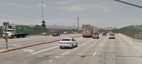
City of Chandler has made a request for TA/CMAQ (see also alameda-drive-tempe-bicycle-pedestrian-proposal for more about TA/CMAQ) funding to add BLs on Chandler blvd between where they stop now (~ 54th St) and continue them to the “far” side of the bridge (City of Phoenix jurisdiction). It’s about .4 miles and the bottom line cost estimate is ~ 600,000 (details are in the link below). The main money driver here is some of the area needs to have curb/gutter/sidewalk relocated in order to make room. See the area on Google Maps. Continue reading “Funding proposal would add BLs on Chandler Blvd over I-10”
Door Zone Bike Lanes figure prominently in the Alameda Drive / Tempe funding proposal
If you’ve never read one of these funding proposals before, they’re pretty interesting. This is one of some number of TA / CMAQ Application for FY 2018, 2019, and 2020 Projects submitted to MAG. Phew, lots of initials: TA / CMAQ Transportation Alternatives / Congestion Mitigation Air Quality. MAG is the Maricopa Association of Governments, who has some sort of process to score these things and recommend (decide?) who gets what. They also have relatively detailed cost estimates, e.g. this project’s bottom line is just shy of $2M total; the kicker is the cost split Continue reading “Alameda Drive Tempe Bicycle / Pedestrian Proposal”
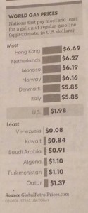
News item, Feb 2016 — Gasoline costs TRIPLE in the Netherlands, and Denmark compared to USA
My notations from the book: City Cycling edited by John Pucher and Ralph Buehler.
John Pucher is arguably the foremost American proponent of separate bicycling infrastructure; often called “Dutch-style”. He is an academic (planner-type; he’s not a traffic engineer) who has many published articles on the subject. And while he is a vociferous advocate for infra, if you read his work fully, he does at least mention there are other factors at play; and furthermore he considers these other factors as necessary to achieve high levels of safety and mode share a la Netherlands or Copenhagen. Among those other factors are, for example, the extremely high costs associated with motoring in those places with high bicycling mode share (duh). In the book, he covers these in the chapter Promoting Cycling for Daily Travel (see below). Here’s a brief excerpt where Pucher explains:
In short, such pro-bike ‘carrot’ policies [e.g. cycle tracks, bike parking] are indeed possible even in a car oriented country like the USA. By comparison, there is almost no political support in the USA for adopting and implementing the sorts of car-restrictive ‘stick’ policies listed in Table 3 [e.g. expensive fuel, high taxes, expensive vehicle parking, restrictive land-use policies] that indirectly encourage cycling in the Netherlands, Denmark and Germany.
He also shows trends for a bunch of countries in fig 2.7 — it would be worth it to put that into Evan’s perspective of looking at the broader traffic safety picture internationally: Traffic fatality reductions: United States compared with 25 other countries in which Evans shows how badly the US is lagging in overall traffic safety compared to virtually the entire rest of the developed world. Continue reading “City Cycling”
This article is to document the problems with the designated bike lane on Warner Road specifically at the intersection with Kyrene in the City of Tempe. Remember, there’s literally no excuse for bad bike lanes; if you can’t build them properly, then don’t build them. Continue reading “Warner and Kyrene”
There is no excuse for improperly engineered bike infrastructure. It takes on two forms, 1) simple straight-up wrong, and 2) “fake” facilities, those which masquerade as something they’re not; they’re in reality nothing more than shoulders, yet they are intentionally tarted-up to appear to be, and even be referred to as bike lanes (see e.g. Flagstaff, below). Continue reading “No Excuse”
I have a lot of thoughts about this stretch of roadway in Phoenix: 48th Street (turns into Guadalupe Rd), north of Piedmont. [google maps]
It involves the odd geographic position of the Ahwatukee area of Phoenix; and the the almost complete lack of connectivity for Ahwatukee residents to anywhere else, (Tempe, Chandler, and indeed the main portion of Phoenix) except by car-choked umteen lane roads.
Ahwatukee is called — sometimes derisively, sometimes happily — the world’s largest cul-de-sac. Setting aside 48th street for a moment; Ahwatukee’s ONLY ingress/egress is Pecos Rd (which is loop 202, a limited-access highway), Chandler Blvd (10 lanes?), Ray Road (10 lanes), Warner Road (only 6 lanes?), Elliot Road (10 lanes?). So these are all either a limited-access freeway, or humongous monstrosities that have interchanges with I-10.
In short, these are all car-choked, car-sewers. They are not particularly bad for cyclists; two (Ray, and Chandler) have wide-curb lanes; Warner has nice narrow lanes; I find Elliot road to be most annoying as it is “critical width“; that is to say not wide yet not narrow enough to be perceived as too narrow to share by many motorists. Yet many cyclists, understandably, don’t want to do it. It is a thoroughly obnoxious experience for pedestrians, too. Continue reading “48th Street; Piedmont to Guadalupe gets SLMs (sharrows)”

 The City of Tempe installed a bike box on the
 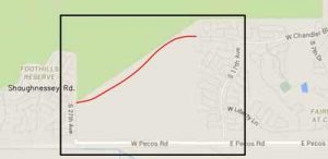 When the final portion of the Loop 202 / South Mountain Freeway (SMF), the part that connects I-10 to Laveen, gets constructed it will replace Pecos Road. Pecos Road in Ahwatukee will be no more. This would otherwise leave everything west of 19th Avenue inaccessible from the rest of Ahwautkee, except for the freeway. The construction of SMF is supposed to begin summer 2016 and opens late 2019.

 Pucher has the same or similar table comparing fatalities/injuries for NL, DK, GER, UK, USA (fig 2.6); i’m sort of confused by the injury rate calculations as