This is pretty interesting for those of us in the Ahwatukee / Chandler area…
[ update: 11/2017 here is the “15%” Initial Project Assessment ; also see below for related update on Phoenix side circa 2020 ]
[Updates, as of early 2022; project is completed, scroll down]
City of Chandler has made a request for TA/CMAQ (see also alameda-drive-tempe-bicycle-pedestrian-proposal for more about TA/CMAQ) funding to add BLs on Chandler blvd between where they stop now (~ 54th St) and continue them to the “far” side of the bridge (City of Phoenix jurisdiction). It’s about .4 miles and the bottom line cost estimate is ~ 600,000 (details are in the link below). The main money driver here is some of the area needs to have curb/gutter/sidewalk relocated in order to make room. See the area on Google Maps.
One facet of what makes this interesting is the ADOT involvement — ADOT generally speaking “doesn’t do bike lanes”; The reason they are ok with it (see the letter attached to the application) is “Support for this project is based on the understanding that the City of Chandler will be responsible for the installation and maintenance of all bike lane markings and signing, in addition to the responsibilities described in the existing Intergovernmental Agreement…” (IGA. Which must exist, but I haven’t seen it, and don’t really know who to ask).
Another facet of interest is the letter of support from Dovalina, City of Phx Streets Director (also attached) which says in part: “Once this segment of BLs in Chandler and across the I-10 bridge is added, the City of Phoenix would consider moving forward in the future with BLs on Chandler Blvd from I-10 to 19th Avenue…”
Although squishy (“would consider”?) that would be a big deal if in fact it were ever carried out. Phoenix currently has BLs on Chandler Blvd only west of Desert Foothills Parkway, about 5 miles miles west of I-10. And by the way, because of the 202/South Mountain Freeway, Pecos Road (1 mile south of Chandler Blvd) goes away.
The proposal does seem to correctly anticipate the need to so some construction and reworking where the existing BL ends westbound at 54th St is significantly sub-standard width . (apparently the original proposal did not encompass the existing sub-standard BLs westbound just east of 54th?! See below for an update) And also to create a BL eastbound at Southgate some realignment/construction/moving the sidewalk will be required.
Sticky wickets I can think of:
1) Is anybody going to sweep the BL (including the bridge)? City of Chandler? Maybe the existing IGA addresses this? And will it be swept often enough? Freeway interchanges attract large amount of debris, that if anything require much more frequent (than a usual BL; which never is enough) sweeping.
Here’s a pic i snapped of the City of Chandler where the Ray Road BL that ends at I-10. Beyond the usual debris, a load of rocks/gravel got dumped in Lane 3, it remained for over a month (pic: https://goo.gl/photos/aqvfJ622zrEp5gzAA). Lane 3 and the RTO lane were cleared within minutes by the natural sweeping action of motor vehicles.
Here’s what that same area normally looks like, it’s hard to tell but there is all manner of not just little stones, but all sorts of metal debris, nails, staples, screws, etc. (pic: https://goo.gl/photos/wW1xhfGU7pgr1Jen7 )
And, by the way, the bridge deck itself, on both Ray Road and Chandler Blvd has an existing wide right lane; and debris simply isn’t much of a problem because and debris gets naturally shoved all the way close to the curb.
(I should mention i regularly cross I-10 at Warner, Ray, and Chandler blvd; and somewhat less regularly at Elliot and Guadalupe. One might wonder– as i do — why the only I-10 bridges for *FIVE* miles are exclusively interchange-mega-arterials)
2) I don’t believe the geometry of the project are specified other than that it’s a “Bicycle Lane (5′ min. with curb/gutter)” (question #2). We would like to see, e.g. the BL meet minimum recommended AASHTO width of 4′ usable where there is a curb/gutter, and note that ADOT uses 2′ gutter pans. See, e.g. this street view with a two foot grate on the EB side of bridge: pic: https://goo.gl/maps/as4MPu3FRtx
The bridge deck itself should not be a problem, it looks like they would just restripe the existing 17′ curb lane into 11′ and 6′. (It should *not* be restriped to 12 and 5).
And that all notwithstanding, although i like “narrow” travel lanes in general, say 10′ because it appears they do tend to have a speed reduction effect on motorists — I do have a problem with a 10′ travel lane adjacent to “narrow” BLs for reasons explained here.
There is a diagram in the application showing a “typical cross section / 130′ total ROW” but I’m not sure that tells me anything.
Here are the project descriptions extracted from the application:
5. Please describe the existing condition of the project site and any problem(s) being addressed.
Chandler Blvd. currently has bike lanes throughout the entire City of Chandler (10.5 miles), with the exception of a small
segment between the I-10 and just east of 54th St. The segment to be addressed has six through lanes varying in width
(10.5′ – 14′), intermittent deceleration lanes (both right-turn and left-turn), median and sidewalks, but no bike lanes. We
have received several resident complaints regarding the lack of bike lanes in this segment and the safety issues this gap
presents. By adding the bike lanes, the safety of cyclists on Chandler Blvd. will be greatly enhanced, and a continuous bike6. Please describe the work being done and improvements being made as part of this project.
This project will add bike lanes to the segment of Chandler Blvd. where they are missing (approximately 0.4 miles). The new
bike lanes will span from just east of 54th St. and will be included on the bridge crossing the I-10. The I-10 bridge is within
ADOT Right-of-Way. ADOT has provided a support letter. Vehicular lanes will be narrowed where possible to make room
for the bike lanes by a simple restripe. Where bike lanes cannot be accommodated by a simple restripe, curb, gutter and
sidewalk will need to be reconstructed to make room for the bike lanes. Additionally, bike racks will be added to the
adjacent bus stops in Chandler.
View the full proposal is at:
www.azmag.gov/Documents-Ext/ModalApps_2018/BP/CHN-20-BPB-001_Complete-Application.pdf
Update 11/15/2016
I was unaware the original proposal did not plan to fix the existing severely sub-standard width BLs westbound, just east of 54th St. A funding addition or whatever it’s called was presented at the 11/15/2016 MAG Bike/Ped Committee meeting, see Chander TIP Amendment Request. This area really needs to be fixed.
Related Update 2020
City of Phoenix resurfaced the brief section between I-10 and 48th street and incorporated (buffered?) Bike lanes, simply by shifting around lane widths. As I mentioned above, Chandler Blvd tends to be vastly wide. This was done presumably as one of many T2050 (a dedicated transpo sales tax) projects. Still no BLs on bridge or the (problematic) Chandler side.
Other nearby T2050 resurface + BL projects in 2020 were 48th St between Fry and Ray (1.5 miles); 36th Street between Ranch Circle N and Equestrian; Knox between 36th St and 48th St; 51st St between Warner and Elliot. Lots of new, smooth pavement!
City of Phoenix Side / 1999 BL plans
Here are Sept 1999 drawings of Chandler Blvd between ~ 42nd St and I-10 showing standard bike lanes between ~ 46th/48th St and I-10. This plan wasn’t implemented, rather it was ultimately done with a wide curb lane instead — presumably because of the short length, only about 1/4 mile.
Update 2021
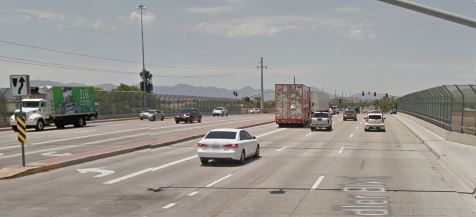
Sometime in late 2021 or early 2022 the project was completed. The bridge section was as simple as adding the BL stripe because the right lane was already (15 feet?) wide. The work on the city of Chandler side involved moving some curbs so was more extensive.
There is now a continuous BL through city of Chandler (east as far as ASU polytechnic which might be city of Mesa, where Chandler Blvd is known as Williams Field road, some 17 miles), over the I-10 bridge, and west as far as ~ 48th Street in Phoenix.
As of July 2021, westbound looks done, so now WB bike lane is continuous over bridge to 48th st in Phoenix. EB construction underway.